Ekskurzija (gorska pot, v časih ozka in izpostavljena)
Alpinistična pešpot (opremljena pot ali zelo izpostavljena, snežišča, skalnati bloki)
R7
Idrija » Planinska koča na Ermanovcu
|
7h00 |
25 km
|
1278 m
|
664 m
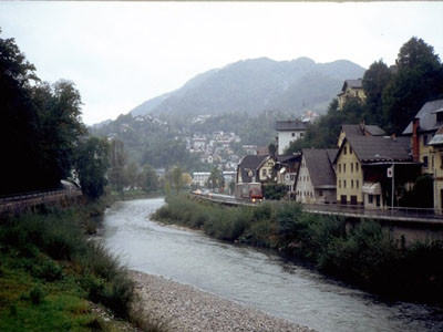
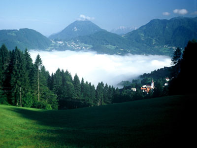
V etapi bomo spoznali Idrijsko in zakorakali v Cerkljansko hribovje. Na začetku nas po strmem vzponu skozi gozd čaka prijetna hoja po hribovitem svetu z veliko gozda in travniki, številnimi kmetijami, cerkvami in naselji. Če smo pozorni, lahko tudi v bližnji okolici opazimo številne cerkve. Hodili bomo nad dolino Idrijce, večinoma po asfaltni cesti, tako da moramo biti previdni.
Z avtobusne postaje v Idriji krenemo po cesti v desno proti vzhodu čez reko Idrijco in po Župančičevi ulici navzgor. Gremo po kamniti stezi v bukov gozd, kjer se strmo vzpnemo nad dolino. Pridemo na kolovoz, po katerem nadaljujemo, pri čemer pot seka ovinke. Sledimo smeri proti vzhodu. Ko pridemo do roba gozda gremo s kolovoza navzgor čez senožet do ceste, ki pelje v vasico Gore. 1h 25 min. Zavijemo v levo po asfaltni cesti po južnem pobočju Cajnega vrha. Ko ga zaobidemo, se lahno spuščamo do zaselka Ledinsko Razpotje, kjer stopimo na regionalno cesto v Spodnjo Idrijo. Po njej v desno, vendar že po 100 m v križišču v levo in po cesti do vasice Pečnik. Po tej cesti gremo samo do križišča, kjer skrenemo s ceste v desno in nato čez planino do vasi Ledine. 1h 30 min. Gremo skozi vas, mimo cerkve na lokalno cesto, po kateri pridemo do partizanskega pokopališča. Ostanemo na cesti, ki se vzpenja po gozdnatem zahodnem pobočju Trepalove Sivke. Pridemo na križišče na prevalu. 30 minut. Nadaljujemo po cesti, ki se spusti do odcepa ceste za vas Žiri v desno. Nadaljujemo še naprej po lokalni cesti proti naselju Sovodenj, vendar že po 5 minutah krenemo na pot čez senožet, ki se odcepi v levo. Po 10 minutah smo ponovno na gozdni cesti pri domačiji. Po njej še približno 10 minut hodimo skoraj po ravnem, nato pa zavijemo v desno do Likarjeve domačije, kjer se cesta konča. Po kolovozu, ki preide v stezo, se strmo spustimo čez senožet do domačije. Kratek čas hodimo po cesti, zavijemo na kolovoz, nad cesto, po katerem se spustimo do naselja počitniških hišic. Tukaj v desno po gozdni cesti do asfaltno ceste pri domačiji Lanišar. 45 minut. Po cesti zavijemo v desno navzgor do prevala, kjer je ob cesti kapelica. Zavijemo na slabšo cesto v desno, kjer se vzpnemo do gozdne ceste, po kateri pridemo do kmetije Pleč, kjer preidemo na kolovoz. Nato gremo čez senožet po potki, do kolovoza, ki nas pelje tik pod Bevkovim vrhom (1051 m). Prečkamo gozdno cesto, mimo velike Bevkove domačije, ter stebrov nekdanjega kozolca do kapelice ob poti. 1h 15 min. Pri kapelici nadaljujemo naprej po travniku, nakar krenemo po gozdu strmo navzdol. Po kratki strmini gremo do kolovoza, nato levo strmo navzdol. Privede nas na travnik, do ceste, po kateri gremo v levo do križišča na prevalu Veharše. Po stezi gremo naravnost v smeri proti severu skozi gozd, čez hribček, ter na drugi strani navzdol čez senožeti do križišča na prevalu. Po kolovozu prispemo na planoto s kmetijo in z nje po poti skozi gozd navzdol do asfaltne ceste na Kladju (787 m). 1h. Prečkamo glavno cesto in po stranski cesti gremo navzgor. Po 30 minutah pridemo do razpotja, kjer se v levo odcepi pot proti Dolenjim Novakom, kamor sicer gre Via Alpina, toda etapo bomo zaključili na Planinski koči na Ermanovcu (968 m). Zato gremo še malo naprej do kmetije Laniščar in pri njej v levo v breg po stezi skozi gozd, kjer zaobidemo vrh Šanc (1048 m), se spustimo nazaj na cesto in po njej do cilja. 30 minut. Za nami je 7h 50 minut hoje. Vir: Dobnik, Jože. (1998). Slovenska planinska pot. Planinski vodnik. Ljubljana: Založba PZS. Atlas Slovenije. (1996). 3. izpopolnjena in razširjena izdaja. Ljubljana: Mladinska knjiga in Geodetski zavod Slovenije (GZS). Škofjeloško in Cerkljansko hribovje. (1993). Izletniška karta. 1:50.000. Ljubljana: GZS. (Peter Šilak)
Naravna in kulturna dediščina
Smo v Idriji, mestu v kotlini sredi hribovite in z vodami ter lesom bogate pokrajine, kar je skupaj z rudo globoko v nedrjih Zemlje pripomoglo k razvoju drugega največjega rudnika živega srebra na svetu, takoj za španskim Almadenom. Nekega večera, leta 1490, je Idrijčan, prebivalec tedaj neznane vasi, namočil nov škaf v vodo, da bi se les napel; zjutraj pa ga ni mogel dvigniti, kajti lesketajoča tekočina - samorodno živo srebro, ki se je nabralo na dnu, je bilo pretežko. To se je hitro razvedelo in v nekaj letih je nastal rudnik, ki je nato nepretrgoma deloval vse do konca prejšnjega stoletja, celih 500 let. Kar 15 nadstropij ali obzorij globoko je segal, iz rude pa so v teh stoletjih pridelali več kot sto tisoč ton te tekoče kovine. Namesto rudarjev danes v rudnik hodijo le še turisti, saj je Antonijev rov, najstarejši del rudnika, preurejen v muzej, kjer obiskovalci s pomočjo multivizije podoživijo življenje rudarjev. Razvoj rudnika je bil tesno povezan z razvojem tehnologije. Marsikaj od dosežkov človekovega uma si je možno ogledati v mestu ali okolici. V divjih dolinah Idrijskega hribovja so zgradili mogočne pregrade, klavže, za katerimi se je nabirala voda, ki je nato odplavila posekan les do Idrije. Tam so bile na reki Idrijci posebne grablje, lesene zapornice, kjer se je ta les, ki so ga v velikih količinah rabili v rudniku, zaustavil. Voda Idrijce, ki je po rakah pritekla do Kamšta, črpalke z velikim, še ohranjenim lesenim loputastim kolesom, največjim te vrste v Evropi, je črpala jamsko vodo iz globin. Tudi jašek Frančiške, odprt konec 18. stoletja, je urejen kot muzejska zbirka starih rudniških strojev, na ogled pa je tudi obnovljena značilna rudarska hiša. V Gradu sredi mesta, kjer je bila nekoč uprava rudnika in skladišča živega srebra, je danes bogato opremljen muzej, kjer izvemo vse o zgodovini rudarjenja in s tem tudi o zgodovini kraja, posebna pozornost pa je posvečena še eni idrijski posebnosti, idrijski čipki. Nežne bele čipke – znanje klekljanja so v Idrijo iz srednje Evrope prinesle žene rudarjev – so pravo nasprotje temnega, grobega in nevarnega podzemlja, ki je krojilo usodo mesta in njegovih prebivalcev. Muzejsko Idrijo z vseh strani obkrožajo strma slemena in visoke planote. Tudi nas pot vodi nanje, na vzhodno stran doline Idrijce, čez strmo pobočje na visoko sleme, ki ga dosežemo pri razglednih Gorah. Sleme, ki spremlja Idrijco, le redko presega tisoč metrov višine (Sivka, Bevkov vrh), ponekod se razširi, da ustvari majhne planote (Ledinska planota), povsod pa na pobočjih in po vrhovih naletimo na manjše zaselke in samotne kmetije. Iz mnogih, predvsem tistih najvišjih, kot je Slabetova pod Bevkovim vrhom, je življenje pobegnilo v doline, na drugih, kot je tista Na ravni, pod istim vrhom, pa se ob kombinaciji domačih, ekološko neoporečnih pridelkov in turizma ohranja vrišč otrok. Viri: http://www.muzej-idrija-cerkno.si/ (Mestni muzej Idrija) http://www.rzs-idrija.si/ (Idrija) (Igor Maher)
Koristni topografski zemljevidi
Škofjeloško in Cerkljansko hribovje ~ Geodetski zavod Slovenije (1 : 50 000)
Koristni pohodniški vodniki
Slovenska planinska pot ~ Planinska zveza Slovenije (ISBN 961-6156-11-x)
Vodnik po planinskih postojankah v Sloveniji ~ Planinska zveza Slovenije (ISBN 961-6156-10-1)
Foto galerija
Dodajte svoje fotografije!
Komentarji
Ljubezen na prvi pogled, kritika? Dodajte svoj komentar k tej etapi. Za bolj splošne opombe uporabite možnost oddaje komentarjev na strani Besede pohodnikov Vie Alpine.
Rembert Biemond - 24.3.31
We did this stage as the previous on out of season, on March 25, 2024.
It is a stage which can be done very well out of season. The initial text on this page is adequate. It starts with a steep climb and then thereafter it is easy, but long. On the Komoot app there is some confusion about the way out of Idrija. Follow the donots as commented earlier (red ring with white in the middle). It is a 25 km stage so it will keep you busy for a while. We actually did some 85% of the route and then diverted to "Forest Paradise" (Google or booking) a B & B. Can be recommended highly. It is just 500 m from the route. We got a fantastic local dish and a great breakfast. Why didn't we go to the Mountain Hut Planinska koča na Ermanovc? Winterclosed! and no Winter Room.
M&M - 23.9.10
Der etwas längere Weg zur Planinska koca na Ermanovcu hat sich für uns auf jeden Fall als gute Wahl erwiesen. Sehr freundlicher Hüttenwirt! Wir waren den ganzen Tag im Regen unterwegs und er hat extra für uns den Kachelofen eingeheizt und wir hatten am nächsten Tag tatsächlich wieder trockene Schuhe.
flautix - 23.8.20
Danke für die Hinweise zur geänderten Wegführung und der Übernachtungsmöglichkeit in Na Lanisah bei Damjian auf dem Baurnhof. Ich habe beides hier in den Track integriert:
https://www.komoot.de/tour/1270649633?ref=wtd&share_token=aS6zOegdFgHfTCUbzG6D9BWFUgjDPNQpdVHDDpM41dt1dZK48n
Neben dem Hochzeitsstadel gibt es über der Gemeinschaftsküche nun sechs schöne Schlafplätze mit Matratzen und Bettwäsche. Man muss also kein Zelt dabeihaben. Wir hatten länger im Voraus per Mail reserviert und Damjans Frau hat uns eine ganze Auswahl an Lebensmitteln für Abendessen und Frühstück in den Kühlschrank gestellt, so dass wir uns bestens selbst versorgen konnten. Übernachtung kostet so 20.- € pro Person plus Kosten für die verbrauchten Lebensmittel. Wir fanden es supernett dort!
Stephanie - 23.5.31
When leaving Idrija, cross the bridge and follow the signs and GPS for route ‘1’ (slovenska planinska pot). Do not follow the GPS for the Via Alpina. When following the ‘1’ you will quickly come across a Via Alpina sign (see photo above). From Ledinsko Razpotje the GPS is correct again.
Ingo - 22.9.17
We followed the comments of Maria, Ludovic and Karsten (below) and went straight to Damians place. We can 100% confirm what they wrote: Damian is a great guy! We simply showed up without calling or writing before, were allowed to camp at his place and had our first real shower in days. He also sold us some food so we didn´t have to go to Cerkno. It was the last chance to buy food in days. There is no shop in Dolenji Novaki (R8)!!!
Bernd - 22.9.1
Wir fanden den Doppelweg zur "na Ermanovzu" (Anmeldung am besten auf Englisch via SMS an die angegebenen Nummer) als lohnend: sehr nette Wirte, große Essensportionen zu verhältnismäßig niedrigen Preisen und am nächsten Morgen konnte man erholt die nahen Infos zu den Rapallo-Vereinbarungen aufnehmen.
Bernd - 22.9.1
Die Wegführung wurde geändert: Es geht nicht mehr zum Marutnik hoch, sondern bald an einer Wegverzweigung mit Infoschild nach links auf einem schönen Waldweg - deutlich weniger anstrengend und in diesem Bereich keine Gefahr, den falschen Weg zu nehmen!
Allerdings an 2 anderen Stellen verstellbare Weidezäune, so dass man ein wenig improvisieren musste (gut auf die Wegmarken achten!)
Julien - 22.8.5
Decided to resupply at Cerkno as it seems a better option than pod brdo. 2 supermarkets but no camping. Spar has much more choice than mercator. Ended up sleeping in a kindergarten next to the volleyball playground. Nice and quiet with water.
Oliver - 22.7.6
The climb out of Idrija is quite steep and partly overgrown with stinging nettles. consider long pants. In ledinsko is a small guesthouse that can be used for first or second breakfasts ;)
Karsten - 22.7.4
I can absolutely confirm the experience of Maria and Ludovic below: The friendly staff of Hostel Idrija had called "Kmetija na Lanisah" and Damian welcomed me at the wedding location some meters after his farm. I was allowed to use the facilities and even sleep in the kitchen due to escape the rain. He even had a beer or me, just bring your own food! When his cows escaped from the paddock later that evening I alarmed hin and chased them back, thus being able to compensate his hospitality a bit ;)
Lovely place (for weddings as well as for tired hikers) and very charming people! Highly recommended to visit them!
Ludovic - 22.6.25
Following Maria's comment (just below) I phoned the owner of the house who I also found on Google Maps (he has a website). And despite the fact that I wanted to sleep there on a Saturday night when a wedding party was going to take place, he kindly offered to come anyway. Arrived when he was in the middle of a rush for the organization of the wedding, he welcomed me with great kindness and arranged for me to take a shower and show me a pleasant and quiet place to put my tent. The place is beautiful and peaceful and I highly recommend as well as Maria!
Maria - 22.5.8
This stage ends at the mountain hut Ermanovcu. We thought it is a pity that the last 2,2km (the end of the stage) is the same as the first 2,2 km of stage R8 (the next day). So we asked the owner of the house right at the junction of the stages (2,2 km before the end of stage 7) if it is possible to camp there. He tells us that he wants to start a campsite and shows us the garden where we can stay, the toilets, the hot shower and the cabin with a kitchen. He also has some mattresses in a cabin. It’s also a wedding location and the view is stunning. Highly recommended! Podlanišče 15, 5282 Cerkno 031 403 762 Mojca info@nalanisah.com www.nalanisah.com
Carsten - 22.1.10
From Idrija to Guest House Kmecki Hram do NOT follow GPS coordinates and official trail description on via-alpina.org (they are WRONG -> no trail). Comments on Maps.Me seem to also direct one to this WRONG route. (AllTrails also uses these wrong GPS data.) Correct: In Idrija, after crossing the bridge and entering the road out of town (as the GPS data indicate), CONTINUE to follow paint marks (red doughnut with white in middle) and hope for the best (you are walking the updated, correct trail but without GPS waymarks). In R7, if one ever finds oneself on an enjoyable, level trail, it’s time to check one’s coordinates. One is almost certainly going in the wrong direction. The guidebook’s altitude gain of 1278m is an underestimate.
Water: pipe out of concrete encasement about half-way through R7 (trickle), and similarly about 85% through (good flow): 46°4’2170N, 14°1’6100E; 46°5’8310N, 14°0’1500E.
Edgard belgian hiker - 21.11.9
Un grand bravo à l'auberge Robert Fortuna à Idrsek qui a ouvert ce lundi 08/11/2021 et m'a préparé un bon repas le soir alors que j'étais le seul client. Le petit déjeuner était gargantuesque. Je valide à 100%.
Gian franco Basso - 19.6.17
dormi a Ermanovcu ou je suis passé en2016 la qualité de la prestation a beaucoup régréssé, propreté douteuse ,repas cher et frugal je ne recommande pas
Samodejni prevod
[Google]
Ostal sem v Ermanovcu, kjer sem ostal v letu 2016. Kakovost storitve je bila veliko pod nadzorom, dvomljiva čistoča, draga moka in skromna, ne priporočam.
POPEYE GG - 18.6.12
13 juin 2017
Là encore, partant déjà de Irdrsek (donc en cours de l'étape R7), je suis allé jusqu'à Dolenji Novaki, au début de l'étape R8: en effet, l'hébergement de fin d'étape R7, Planinska Koca na Ermanovcu n'est ouvert qu'en fin de semaine ou alors il faut téléphoner (pas facile comme d'habitude à cause de la langue), et en plus on évite un aller et retour.
Ai passé la nuit à l'hôtel Gacnik aux coordonnées N46°08,733 E14°01,568 (il faut prendre à droite sur la route en sortant du chemin, pas de fléchage!).
Samodejni prevod
[Google]
13. junij 2017 Še enkrat, ko sem že odšel iz Irdrseka (tako v fazi R7), sem šel v Dolenji Novaki, na začetku etape R8: zares, končna stopnja R7 Planinska Koča na Ermanovcu je odprta šele ob koncu tedna ali pa moraš poklicati (ni tako lahko kot običajno zaradi jezika) in ne moreš iti naprej in nazaj. Prenočili v hotelu Gacnik na koordinatah N46 ° 08,733 E14 ° 01,568 (zavijete desno na cesto in ne smete!).
Nice people at the restaurant though. Hiking from Idršek to Idrija was kind of a search, there was a sign that leads you into the forest, but the path is blocked with fallen trees and totally overgrown after that. I had fight my way through the forest to get back to the road (which is actually the GPS track).
The youth hostel in Idrija is a nice and cheap place to stay (€11,08 pppn). I was alone in the dorm :-).
Samodejni prevod
[Google]
Čeprav so v restavraciji dobri ljudje. Pohod od Idrška do Idrije je bil nekakšno iskanje, bil je znak, ki vas pripelje v gozd, vendar je pot blokirana s padlimi drevesi in potem popolnoma zarasla. Skozi gozd sem se prebil, da bi se vrnil na cesto (ki je pravzaprav GPS-sled). Mladinski hostel v Idriji je prijeten in poceni prostor za bivanje (11,08 pppn). Bil sem sam v domu :-).
Maybe I misunderstood the symbols, but also in Idršek is no grocery store or what so ever.
Samodejni prevod
[Google]
Mogoče sem napačno razumel simbole, ampak tudi v Idršku ni nobene trgovine ali kaj tako.
knfkwnfvw - 17.8.31
test
Samodejni prevod
[Google]
test
Klaus - 16.9.16
Ermanovcu dom ist die erste Berhütte auf dieser Tour: kleine Schlafräume mit (warmer) Gemeinschaftsdusche und atemberaubendem Ausblick von der Terrasse.
Leider spricht weder der nette Padrone, noch seine 5 anwesenden Landsleute irgendeine Fremdsprache. Aber für Gulasch mit Polenta, einem Tomatensalat und 3 Bier reicht es. Incl. ÜN/F kostet alles 27€!
Samodejni prevod
[Google]
Ermanovcu dom je prvi Berhütte na tej turi: majhne spalnice z (toplo) komunalno prho in osupljiv pogled s terase. Na žalost niti čudoviti Padrone niti njegovih 5 rojakov ne govorijo nobenega tujega jezika. Ampak dovolj za golaž s polento, paradižnikovo solato in 3 piva. Vklj. Nočitev / F stane 27 €!
Klaus - 16.9.16
Tour 14.09.2016 - 9h
- 1:45 Aufstieg senkrecht im Wald ohne Serpentinen und mangelhafter Markierung.
- 1h Schotterweg bis zur 3-Sterne Pension Fortuna, die aber erst um 12:00 öffnet.
- 4:15 mit guter Wegeführung aber wiederum schlechter Markierung bis zum Bevkov Vrh.
- 2h auf größtenteils Asphalt-/Schotterstraße stetig bergan bis zur Ermanovcu koča (dom).
Samodejni prevod
[Google]
Ogled 14.09.2016 - 9h - 1:45 vzpon v gozd brez serpentin in slabo označevanje. - 1 h makadamske ceste do penziona Fortuna s 3 zvezdicami, vendar se odpre le ob 12.00. - 4:15 z dobrimi potmi, vendar znova slabo do Bevkovega vrha. - 2h na pretežno asfaltni / makadamski cesti navzgor do Ermanovecke koče.
Elisabeth - 12.11.30
Le début de l'étape est très mal expliqué. Encore un refuge fermé en semaine ! C'est le 3e...Heureusement, je randonne en autonomie complète. A noter qu'il est alors inutile de faire l'AR depuis la ferme Laniscar : la suite de l'itinéraire se prend en dessous de la ferme. L'étape dure au moins 8h.
Samodejni prevod
[Google]
Zgodnji fazi je zelo slabo pojasnil. Druga zavetišče zaprto teden! To je tretja ... Na srečo sem pohod v popolni avtonomiji. Upoštevajte, da ni treba, da to storijo, saj kmetije AR Laniscar: Po poti pod kmetijo. Faza traja najmanj 8 ur.
Check in the Idrija Tourist Office the availability of the Refuge of Ermanovca! They will phone to announce you are coming. The place is not frequented much, and closed on Mondays and Tuesdays.
Samodejni prevod
[Google]
Prijava turističnega urada Idrija razpoložljivost zatočišče Ermanovca! Bodo telefon sporočamo, da prihajajo. Kraj je ne obiskujejo veliko in zaprto ob ponedeljkih in torkih.
Alpinisten - 11.9.26
Achtung!Wenn man auf dem mit einer 1 markierten Weg aufsteigt, dann nicht fälschlicherweise oben nach rechts Richtung Gore dem Wanderzeichen folgen, sondern auf dem Makadamweg Ausschau halten nach einem weiteren Zeichen, das den richtigen Weiterweg geradeaus oder nach links markiert. Wir hatten das übersehen und liefen daher 2 Stunden unbemerkt in die falsche (südliche) Richtung. Der Weg war so schön, daß wir unsren Fehler erst in Urbanovc bemerkten...zum Glück konnte uns dann eine Bäuerin weiterhelfen, indem sie uns ein Stück zurück fuhr, sonst wären wir wieder in Idrija gelandet.
Samodejni prevod
[Google]
Opomba: Če ste vzpon na označena z 1 način, potem napačno zgoraj desno v smeri Gore po označeni poti, vendar ne na razgledni za makadamu še en znak, da je ravno prav ali če tako oznako na levi strani. Imeli smo zamudili 2 uri in je zato tekel neopaženi v napačnem (jug) smeri. Cesta je bila tako lepa, da smo opazili napako unsren do Urbanovc ... Na srečo smo lahko nato pomagajo kmeta, tako da nam je kos recoiled, sicer bi pristali v Idriji.
Alpinisten - 11.9.8
Wegen eines Gewitters mußten wir unsere Route leicht abändern und liefen anstelle zur Planinska koca na Ermanovcu nach Cerkno. Im "Hotel Cerkno" kann man wunderbar die regionale Küche genießen und sich im benachbarten Schwimmbad etwas erholen, wenn man sich einen Tag Pause im Hotel gönnen möchte. Man steigt ab hier 4h30 zum Porozen-Gipfel auf. In Cerkno ist die Wegmarkierung etwas versteckt.
Samodejni prevod
[Google]
Zaradi neurja smo imeli nekoliko spremenimo naše poti in tekel namesto tega Planinska koča na Ermanovcu v Cerkno. V "Hotel Cerkno", se lahko sprostite in uživajte domače kuhinje in se sprostite v sosednjem bazenu malo, če želite, da si privoščite dan počitka v hotelu. Povzpnete od tu na 4:30 Porozen vrhu. Cerkno poti Marker se nekoliko skrita.
Apartma Rožica lies in the city centre of town Idrija and offers affordable accomodation with breakfast in rooms with air-conditioning, mini-bar, 24/7 Wifi high-speed Internet access and cooking facilities. The Family informs you about local sights, dishes and possibilities. Warmly recommended to all long-distance hikers going across Via Alpina!
Samodejni prevod
[Google]
Apartma Rožica leži v središču mesta Idrija in ponuja cenovno ugodno namestitev z zajtrkom v sobi s klimatsko napravo, mini-bar, 24/7 WiFi visoke hitrosti dostopa do interneta in opremo za kuhanje. Družinska vas obvešča o lokalnih znamenitosti, jedi in možnosti. Toplo priporočamo vsem dolge razdalje pohodnike gredo čez Via Alpina!
robert - 11.7.11
Mardi 14 juin 2011, le refuge était fermé; il y avait cependant une cabane en construction qui permettait un bivouac confortable et abrité de la pluie .Aller chercher de l'eau auprès des fermes en contrebas du refuge (500m)
Samodejni prevod
[Google]
Torek, 14. junij, 2011, je bil zaključen zatočišče, vendar pa je bila koča v gradnji, ki je omogočil udoben bivak in zaščitena pred dežjem. Pridobivanje vode iz ribogojnice pod koče (500m)
gonzom - 10.8.10
Someone confuse "left"and "right" , "up" and "down" in the description of this stage!
Samodejni prevod
[Google]
Nekdo je zamenjal "levo" in "desno", "gor" in "dol" v opisu tej fazi!

 |
7h00 |
25 km
|
1278 m
|
664 m
|
7h00 |
25 km
|
1278 m
|
664 m


Ljubezen na prvi pogled, kritika? Dodajte svoj komentar k tej etapi. Za bolj splošne opombe uporabite možnost oddaje komentarjev na strani Besede pohodnikov Vie Alpine.