Randonnée (sentier de montagne, parfois étroit et exposé)
Randonnée alpine (passage équipé ou très exposé, névé, blocs)
R40
Kellerjochhütte » Schwaz
|
6h05 |
15.7 km
|
614 m
|
2063 m
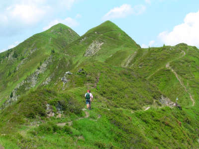
Une étape offrant de beaux points de vue et se terminant par Schwaz et ses mines d’argent. La montée au refuge Kellerjoch est assez raide, mais le confortable refuge saura répondre à toutes les attentes du randonneur. Soit par l’ancien refuge Alte Kellerjochhütte, soit en suivant la crête vers le col Kreuzjoch et le Gratzenkopf, on arrive à la ville de Schwaz, connue pour ses mines d’argent.
Au col de Loassattel, prendre le sentier en direction du refuge Kellerjochhütte en revenant un peu en arrière (depuis le Gamsstein ou l’auberge Loas) et en montant sur la gauche. Le sentier est assez raide, passant tout d’abord par des forêts clairsemées offrant peu d’ombre, puis par de la laîche fausse-brize avec des roses alpines et des pins. Mis à part le fait qu’il puisse faire assez chaud, la montée offre une vue magnifique sur le Karwendel, la vallée de l’Inntal et les pics Sonntagsköpfel et Gilfert. Juste en-dessous du sommet Kuhmöser, le sentier s’aplanit et longe le versant. De là, on peut déjà voir le refuge Kellerjochütte, d’où la vue est particulièrement belle. Une dernière montée permet d’y arriver en 2h au total. Pour la descente, plusieurs possibilités : pour les personnes qui ont le vertige, la descente par le refuge Alte Kellerjochhütte et l’alpage Proxenalm est recommandée. Ceux qui n’ont pas peur du vide et qui ont un bon pied devraient opter pour le très pittoresque « Alpinsteig » (sentier alpin) après la chapelle. Juste derrière le refuge, un sentier sécurisé par des cordes mène à la chapelle du col de Kreuzjoch (approx. 30min). De là, un sentier raide descend au col de Kellerjoch, où il faut suivre les panneaux pour Gratzenkopf. On peut déjà facilement distinguer le sentier depuis le col de Kellerjoch qui passe par la crête. Aux deux prochaines bifurcations dans la route, rester à gauche pour atteindre la croix du sommet du Gratzenkopf (1h30). Après le Gratzenkopf, le sentier descend par une courbe sur la gauche. Au début, il passe par des herbes hautes (attention aux glissades en cas d’humidité), puis devient plus étroit à travers des bois de plus en plus denses jusqu'à arriver à la route forestière venant de l’alpage Proxenalm. La suivre sur la droite avec les panneaux indiquant « Schwaz – Zintberg – Pirchner Aste ». Plusieurs changements de direction dans la forêt sont bien signalés en rouge. L’auberge Pirchner Aste à mi-chemin dans la descente propose une restauration. Une dernière tirée à travers bois permet de rejoindre la route goudronnée du mont Zintberg. La suivre par de nombreux virages en épingle pour arriver à la ville argentifère de Schwaz (1h30 depuis le Pirchner Aste). Pendant la descente on peut voir le château Schloss Freundsberg, qu’il est facile d’atteindre par un détour. Depuis la route forestière à l’alpage Proxenalm, le sentier bifurque sur la gauche vers le Gratzenkopf. Chercher les panneaux et veiller à ne pas les manquer. (Christina Schwann, OeAV)
Patrimoine naturel et culturel
La chaîne montagneuse de Kellerjoch, en forme de fer à cheval, est la plus élevée au nord est des Alpes de Tuxer. Les pics relativement modestes ne doivent pas être sous-estimés, car le dénivelé de 1 800m avec l’Inn fait de la crête un point d’observation idéal sur la vallée de l’Inntal. Depuis le refuge Kellerjochhütte de la section Schwaz du Club alpin d’Autriche, il est possible d’atteindre la petite chapelle du col de Kellerjoch en passant par un sentier est exposé mais sécurisé. La vue est très belle sur les monts Karwendel et la vallée de l’Inntal. Protégée par les hautes montagnes du nord et les pics des Alpes de Tuxer, au sud, qui laissent passer suffisamment de soleil, la vallée de l’Inntal bénéficie de conditions climatiques très favorables. De plus, les vents chauds de Foen ont un effet positif sur la végétation (à l’exception des plantes particulièrement sensibles aux variations climatiques). Dans le passé, la vallée de l’Inntal était une zone à prédominance marécageuse, mais aujourd’hui son apparence est avant tout influencée par l’agriculture, les zones industrielles et l’autoroute. La descente par le mont Zintberg mène à la bifurcation pour le Château Freundsberg, dont les tours abritent le Bergbau- und Heimatmuseum (musée minier et d’histoire locale). Le château est l’un des symboles utilisés pour présenter le bas de la vallée de l’Inntal. La première cérémonie de baptême remonte à l’an 1128. L’exploitation minière a toujours joué un rôle de taille à Schwaz, la « ville d’argent ». La richesse économique de la ville au 15ème siècle a également eu un effet extrêmement positif d’un point de vue culturel. Et même si la ville a été détruite dans sa quasi-totalité par les flammes durant les guerres de libération du Tyrol en 1809, de nombreuses constructions témoignent encore du rayonnement passé. L’église paroissiale, la plus grande église gothique du Tyrol, le monastère franciscain avec son cloître, la Fuggerhaus (maison marchande familiale) et la mairie font partie des bâtiments les plus intéressants à visiter. Des personnages tels que Hans Sachs, Paracelse ou l’Empereur Maximilien au 15ème siècle séjournèrent dans la ville d’argent. Même aujourd’hui, des artistes mondialement connus se réunissent dans cette belle ville du bas de la vallée de l’Inntal. À noter : le « Klangspuren-Festival » et le « Avantgarde Schwaz », dont la portée dépasse largement les limites du Tyrol. (Christina Schwann, OeAV)
Autres grands itinéraires et variantes
Ascension du Kuhmöser, montée au col de Kreuzjoch (2 344m), chapelle.
Cartes topographiques utiles
Nr. 5/3 Karwendelgebirge Ost ~ Oesterreichischer Alpenverein (1:25.000)
Coup de cœur, critique ? Entrez votre propre commentaire sur cette étape. Pour des remarques plus générales, merci d’utiliser la fonction commentaire de la page La parole aux Via Alpinistes.
Carsten - 10/01/2022
[4] Excellent resupply in Schwaz. Start at the Stadtgalerien (just before the river, on the left, the Via Alpina passes it, with supermarket as well as DM and Muller markets, the latter two carrying their usual range of health foods). Past the train station (whose pedestrian underpass one has to use) is a Hofer/Aldi. Prices in Schwaz are about half of what they were in Sexten or Finkenberg.
Carsten - 10/01/2022
[3] About 5km before Schwaz one reaches an asphalt road and a bus stop, Pertrach (buses run almost every hour to Schwaz). The guidebook says walk the road into town. The app Maps.me shows a hiking trail that takes off in the second far (East) curve down; signposts appear 5min into the trail, but where it starts from the asphalt road there is only a sign about a "Rodelbahn"; this somewhat rough trail descends rapidly along a creek and then moves diagonally away from the creek, crosses the asphalt road, and continues as a forest trail to the
very edge of Schwaz. Another option at Pertrach is to follow the signs to "Burg Freundsberg" with a trail that seems to continue through nice old forest; the GPS waypoints for the Via Alpina lead to within 300m and 100m altitude (below) the Burg, so from the Burg it's just a matter of descending to rejoin the GPS route.
Carsten - 10/01/2022
[2] If one goes to the Kellerjochhuette, one has 3 possibilities to continue: (1) Follow the GPS waypoints, which means an about 2km slope crossing (the slope is at a 70-80 degree angle but the trail is good, albeit narrow, early on secured with c.200m of cables that aren't necessarily needed, and the slope is covered in grass and small bushes), or (2) walk around the Kellerjochhuette and find the spur trail down to the highline trail (from afar, this looked like the easiest option; it will likely provide an incentive to bypass the Gratzenkopf, or (3) continue from the hut to the chapel and continue from there to rejoin the GPS waypoints; the trail to the chapel (300-500m) may look challenging, being secured with cables in the beginning, but to judge from conversations with other hikers, could yet be easier than (1) (which I took).
Carsten - 10/01/2022
[1] Ascending towards the Kellerjochhuette from the Gamssteinhaus at the beginning of R40, after about 15 minutes signposts give two options to reach the Kellerjochhurtte: straight up, or via a highline trail ("Hochebenweg") circling around the mountain and then ascending a spur to the hut. Both are signposted with the same time (I think it was 1 3/4 hours). Unless one wants to spend the night at the hut or for some other reason wishes to go up there, the highline trail *without* final ascent (bypass the hut, since one has to descend to 550m altitude Schwaz afterwards -- why add another 500m elevation gain to what’s already a big drop?) for no real gain -- may well be preferable. Where the spur trail branches off the highline trail to go up, one can continue the highline trail and either start descending to Schwaz (on trails) or continue in order to rejoin, after a bit of ascent, the GPS waypoints of the Via Alpina to go to the Gratzenkopf (a lower peak).
Lolo - 31/07/2019
Hebergement à Schwaz à Einhorn Schaller...très bien (56€ : nuit + petit dej). Resto fermé ce jour là.
POPEYE GG - 01/02/2019
Dimanche 17 juin 2018
Descente aisée sur Schwaz (nous en avions fait la moitié la veille pour cause de difficulté d'hébergement!).
A Schwaz, personne à la Pension Clara; il y avait la fête du village, peut-être en est-ce la raison?
Du coup, nous avons filé jusqu'à Stanz, sur l'autre rive de l'Inn, pour nous rapprocher un peu pour l'étape suivante. Nous avons trouvé à l'Hotel Garni Appartments Kastner (130€ pour 3).
Gamssteinhaus was closed (on a Saturday), but it's a great camping spot. Unfortunately I couldn't do the ridge hike to the Kellerjoch Hütte, the weather was too unstable, but there is a good alternative route that goes via Proxenalm.
Traduction automatique
[Google]
Gamssteinhaus était fermé (un samedi), mais c'est un super camping. Malheureusement, je ne pouvais pas faire la randonnée sur la crête jusqu'au Kellerjoch Hütte, le temps était trop instable, mais il existe un bon itinéraire alternatif qui passe par Proxenalm.
In Schwaz you will stay at Pension Clara, just some 100m from the stage end-point. €38 B&B. Ask anybody for the way. Or walk down to the river, and turn right 300m to the tourist office.
Traduction automatique
[Google]
À Schwaz, vous séjournerez à la pension Clara, à seulement 100 mètres du point d'arrivée de la scène. 38 € chambres d'hôtes. Demandez à n'importe qui pour le chemin. Ou bien descendez jusqu'à la rivière et tournez à droite sur 300 m jusqu'à l'office de tourisme.
Elisabeth - 24/12/2012
Depuis le refuge Kellerjochhütte, la variante par le Gratzenkopf est jolie mais beaucoup plus longue.
Jean-Louis GIRAUD - 28/03/2012
Compte tenu du trés mauvais temps et des prévisions météo, je n'ai pas souhaité dormir à SCHWAZ mais plutot avancer sur la prochaine étape R41...Je me suis finalement arrété au monastère Bénédictin de St GEORGENBERG-FIECHT. Ce soir là , il y avait de la place et j'ai été trés bien accueilli .
J'ai également pris le repas du soir et le petit déjeuner dans un réfectoire de l'abbaye .
Von der Rastkogel oder kellerjochhütte zweiegt der "INntaler Höhenweg" Richtung Innsbruck ab, das ist eine Variante des Roten weges, über Lizumer- und Glungezerhütte zum Patscherkofel. Details unter www.glungezer.at
Traduction automatique
[Google]
De l'zweiegt Rastkogel ou Kellerjochhütte de la «piste Inntaler" en direction d'Innsbruck, qui est une variante de l'itinéraire rouge, pour environ Lizumer et Glungezerhütte Patscherkofel. Détails sur www.glungezer.at

 |
6h05 |
15.7 km
|
614 m
|
2063 m
|
6h05 |
15.7 km
|
614 m
|
2063 m


Coup de cœur, critique ? Entrez votre propre commentaire sur cette étape. Pour des remarques plus générales, merci d’utiliser la fonction commentaire de la page La parole aux Via Alpinistes.