Create your own guidebook
Download track
Quality : rough
GPX KML CSV
Location
Italy
Friuli Venezia Giulia - Veneto
Pordenone - Belluno
Cimolais - Domegge di Cadore
Spalti di Toro - Monfalconi - Val Talagona
Parco nat. Prealpi Carniche - Biotopo Val Talagona
Key to symbols   
Stage point (start or end of stage)
Intermediate accommodation possibility
Summit
Pass
Town, village
Other locality

Catering
Doctor
Chemist
Bakery / grocery
Hardware / sports shop
Post
Bank / cash dispenser
Train
Coach
Taxi
Open automobile access

A Tarred or paved road
B Dirt track
C Mule trail
D Mountain trail
E Equipped trail (cables, ladders)
F No trail

Stroll / tourism (broad, non-exposed trail)
Hiking (mountain trail, in places narrow and exposed)
Alpine route (equipped or very exposed section, snow field, blocks)
B17 Rifugio Pordenone » Rifugio Padova
  |   4h50   |   8 km   |   1165 m   |   1127 m

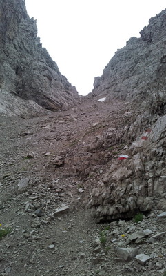
The route passes the steeple of Val Montanaia and then heads up to the Montanaia pass. Here, a difficult trail leads down into Cadin d’Arade Valley until it meets Pra di Toro Valley and the Padova hut.

Point Segment
Name Services Information Marking
Rifugio Pordenone
1249 m
| D  3 km / 2h30
Val Montanaia - Bivacco Perugini
2060 m
| E  1 km / 0h50
F.lla Montanaia
2333 m
| D  4 km / 1h30
Rifugio Padova
1287 m
Detailed route description
Natural and cultural heritage
Other long-distance trails and alternative routes
Alta Via n. 6 dei Silenzi trail.
Useful topographic maps
  • 02 e 016 ~ TABACCO (1:25000)
  • Foglio B ~ TABACCO - Carnia Trekking (1:25000)
Useful guidebooks
  • Dolomiti di Sinistra Piave e prealpi carniche ~ Edizioni Dolomiti (ISBN 88.85080.04.9)
  • Dolomiti Orientali - vol. II ~ CAI - TCI (ISBN )
  • Alta Via n. 6 dei Silenzi ~ Guide Tamari n. 8 (ISBN )
  • Via Alpina Gelber Weg, Evamaria Wecker ~ Bruckmann (ISBN 978-3-7654-4858-7)
Comments

Favourites, criticisms ? Make your personal comments on this stage. For more general notes please use the comments section of the page Over to the Via Alpinists.


max. 1000 characters
  • sahibvoyageur - 2023-07-07
    La descente du col vers Padova se fait bien en ramasse en restant sur les traînées de cailloutis instables. Je déconseille cette étape dans le sens Padova / Pordenonne.
  • Po & Ju - 2018-11-06
    Montée au campanil (clocher) di montagna : dingue ! Bivouaco au pied du campanil. La decsente apres le col est un grand pierrier raide. Avoir le pied sur et faire attention. Le refuge padova est une grosse usine familiale puisque la route y mène. L'étape est petite mais intense.
    Automatic translation [Google]
    Ascent to the campanil (bell tower) di montagna: crazy! Bivouaco at the foot of the campanil. The descent after the pass is a large steep scree. Have your foot on and pay attention. The padova hut is a big family factory since the road leads to it. The stage is small but intense.
  • frankie9594 - 2018-05-18
    Monaco- Trieste

    This can be a dangerous stage, caution is advised. Do not attempt this hike in rain, or at the end of the day. Walking sticks are advised as well.
  • Jean-Louis Giraud - 2014-03-06
    Etape exigeante dans un environnement sévère. La montée vers La Forcella Montanaia s'effectue sans grosses difficultés dans les eboulis avant de poursuivre sur la droite d'un monolithe, puis rejoindre la brèche par un cheminement dans la pelouse alpine et un dernier ressaut rocheux.
    La descente demande attention et vigilance. Le jour de mon passage le haut du couloir était barré par un névé qui empéchait tout cheminement sur le flanc gauche, vers les traces de descente. Sous la pluie, j'ai traversé ce névé pour rejoindre les pierriers au centre du couloir. Aprés plusieurs tentatives pour descendre en suivant le balisage sur ce terrain instable et relativement pentu, j'ai finalement opté pour une descente directe et rapide au milieu du couloir avant de retrouver des traces, puis le sentier, plus bas dans le Cadin d'Arade.
    Au final une vraie étape alpine repérée EE sur la carte consultée au refuge Pordenone.
    Absence de point d'eau sur l'itinéraire ...
    Automatic translation [Google]
    Demanding step in a harsh environment. The climb to the Forcella Montanaia occurs without major difficulties in scree before continuing on the right of a monolith, then join the breach through a path in the alpine grass and a rocky last jump. The descent requires attention and vigilance. The day I passed up the hall was blocked by a snowfield that wont any path on the left, to the traces of descent. In the rain, I crossed the snowfield to reach the scree at the center of the corridor. After several attempts to go down following the markup on this relatively unstable and steep terrain, I finally opted for a direct and rapid descent through the corridor before finding traces, and the trail further down the Arade Cadin . Finally a true alpine stage marked on the map EE consulted refuge Pordenone. No water point on the route ...
  • Thierry M - 2014-01-27
    August 2013. trail up to Forcella Montanaia was marked and obvious.
    Going up right as close to the rocks, or going down to the left
  • Thierry M - 2014-01-27
    Monaco - Trieste
    Bivacco Perugini has a great location (no water tho)
    rif Padova - Bivacco Perugini about 2h30.
    an extra 1h30 to get down to rif Pordenone in the amazing peaceful Meluzzo valley
    the way to F. Montanaia is very steep and unstable (few times need to use the hands but no big deal, probably harder to get down from F Montanaia towards rif Padova)
  • M.Keller - 2013-03-20
    Dans le sens R.Padova - R.Pordenone
    La montée de la la brèche Montanaia présente des risques surtout après de grosses pluies (comme ça a été le cas pour moi), car les traces ne sont pas très apparentes, le terrain est instable et la pente est forte. On ne sait pas exactement où passer. Pour moi, cette étape a été la plus difficile de la voie jaune.
    Automatic translation [Google]
    In the sense R.Padova - R.Pordenone The rise of the gap Montanaia this risk especially after heavy rains (as was the case for me), because the traces are not very apparent, the ground is unstable and the slope is steep. We do not know exactly where to spend. For me, this step was the most difficult of the yellow path.
Last update : 2013-10-09