Hiking (mountain trail, in places narrow and exposed)
Alpine route (equipped or very exposed section, snow field, blocks)
A39
Maria Alm » Riemannhaus
|
4h25 |
10.1 km
|
1329 m
|
0 m
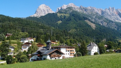
From Maria Alm, the trail first goes through the locality of Maria Alm and along the Grießbach stream directly to the foot of the Steinerne Meer mountains. The climb to the Riemannhaus lodge is quite steep. The many stone steps will make the climb through the solid limestone face up to the Ramseidener Scharte gap easier.
Cross the stream in Maria Alm, keep right just after the bridge and follow the course of the Grießbach stream into the Grießbachwinkel valley. Walk on a slight incline along the asphalt road, continuing with the Steinerne Meer mountains just before you. At the fork in the road, keep to the left in order to arrive at the Riemannhaus car park. From here, go through the wood, first left then immediately to the right, always following the signs in the direction of "Riemannhaus". After a longer stretch of forest road, you will reach the upper car park and a barrier. This is where the Kalkhochalpen nature reserve begins. The vegetation becomes increasingly lighter and there is an impressive view over the Breithorn towering before you on the left and the Sommerstein to the right. Continue steeply uphill over the "Sandten". A look back over your shoulder is well worth it on clear days, as you will see the Zellersee lake and the glacier-eroded Kitzsteinhorn peak in the distance. The trail swings left to the "Fürstenbrünnl" and the "Bilgerirast", a spring at which it is possible to fill your water bottles once more. A little further up, the route branches off over the south wall of the Breithorn, although this is reserved for very experienced mountaineers due to its level of difficulty. On arriving at the lower end of the goods lift, this is where the really steep climb to the Riemannhaus begins. Numerous stone steps carved into the rock and wire cables make the climb easier, although the trail is sometimes rather exposed. On good days, it can also be rather hot and you are advised to bring sufficient water with you, as there are hardly any springs in the karstic limestone. Once you have crossed the Ramseider Scharte pass, you will practically be standing at the foot of the Sommerstein, which is also know as the "Eule" (owl), as the caves look like two big eyes. The Sommerstein is a popular mountain for climbing, although the routes range in difficulty between levels 8 and 9. Various other routes around the Riemannhaus refuge have been closed in recent years. More detailed information can be obtained at the Riemannhaus (approx. 4h 25min). The Sommerstein can be climbed more easily from the rear of the Riemannhaus refuge in approx. 20min. The view is marvellous with the green woods of Maria Alm, the Saalfelden basin and Zell am See stretching out on one side and the uncultivated terrain of the Steinerne Meer mountains on the other. The Breithorn can be scaled in approx. 30min from its North side taking the normal upward trail. From there, a climbing trail leads over the Mitterhorn and the Persailhorn to the Peter-Wiechenthaler-Hut. The Schönfeldspitze peak comes highly recommended for a detour. Its large wooden cross is known well beyond the borders of Salzburg. The climb via Schönegg and Wurmkopf is really beautiful, but you must be sure of foot and free of vertigo. Just below the summit of the Schönfeldspitze, another very exposed and thus difficult stretch must be tackled, but the view is magnificent. (Christina Schwann, OeAV)
Natural and cultural heritage
Maria Alm is a well-known place of pilgrimage. The Bartholomäus pilgrimage takes place at the end of August, during which the pilgrims walk from Maria Alm over the Steinerne Meer mountains to St. Bartholomä in Berchtesgaden. The origins of this pilgrimage are unknown. According to legend, a bear once tore a farmer limb from limb. An image of the Virgin Mary was brought to the site of the accident on the Schattberg mountain. Prayers are said to have been answered again and again here. A chapel was therefore established and over time, this gave rise to a real pilgrimage. The trail through the Grießbach stream and up the steep steps to the Riemannhaus lodge is an exhausting one, particularly for the pilgrims who carry the image of the Virgin with them. Via Alpina follows the same trail via the house of the German Alpine Club, which is set in a glorious location at the foot of the Sommerstein with a magnificent valley view over the entire Saalfelden basin as far as Zell am See and the Kitzsteinhorn. The ascent of the Schönfeldspitze, which requries hikers to be sure of foot and free of vertigo, is a paritcularly special experience. The summit cross is a major work of art: the Virgin Mary holds the body of Jesus taken down from the cross in her arms. A special place, not only because of the glorious panoramic view over the Watzmann massif, the Königsee lake, the Leoganger Steinberge, Hohen Tauern and Höchkönig mountains. Here, regardless of whether you religious or not, you feel the presence of a superior power, which inspires humility and an appreciation of creation. (Christina Schwann, OeAV)
Other long-distance trails and alternative routes
Route to the Riemannhaus lodge also via Saalfelden, connection to the federal railways. Saalfelden via Ramseidener Steig track, which meets Via Alpina in the Bilgerirast area. north alpine trail 01 (E4 alpin), Rupertitrail 10 (E10)
Favourites, criticisms ? Make your personal comments on this stage. For more general notes please use the comments section of the page Over to the Via Alpinists.
Christina, ÖAV - 2015-06-30
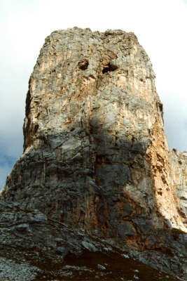
Der Anstieg zum Riemannhaus ist im oberen Bereich sehr steil. Steinstufen, ein paar Eisentritte und ein Seil erleichtern den Aufstieg. Trittsicherheit und Schwindelfreiheit sind erforderlich, wobei es im Aufstieg leichter ist, als im Abstieg. Klettersteigausrüstung ist nicht erforderlich. Ein Bild findet sich hier oberhalb.
Automatic translation
[Google]
The increase for Riemannhaus is very steep at the top. Stone steps, a few metal rungs and a rope to facilitate the ascent. Surefootedness and head for heights are required, it is easier on the rise, as in the descent. Climbing equipment is not required. An image can be found here above.
Christian - 2015-06-30
Wir wollen die Etappe über das Steinerne Meer machen. Der Aufstieg zum Riemannhaus wird überall unterschiedlich beschrieben. Teilweise wird Klettersteigausrüstung empfohlen. Wie schwierig ist der Aufstieg nun wirklich. Gibt es Bilder zu den schwierigen Stellen? Danke im voraus!
Automatic translation
[Google]
We want to make the stage over the Stony Sea. The ascent to Riemannhaus describes different everywhere. Partly climbing equipment is recommended. How difficult the climb is really. Are there any pictures of the difficult places? Thanks in advance!

 |
4h25 |
10.1 km
|
1329 m
|
0 m
|
4h25 |
10.1 km
|
1329 m
|
0 m


Favourites, criticisms ? Make your personal comments on this stage. For more general notes please use the comments section of the page Over to the Via Alpinists.