Parco Naturale Alta Valle Pesio e Tanaro / Parc National du Mercantour
Key to symbols
Stage point (start or end of stage)
Intermediate accommodation possibility
Summit
Pass
Town, village
Other locality
Catering
Doctor
Chemist
Bakery / grocery
Hardware / sports shop
Post
Bank / cash dispenser
Train
Coach
Taxi
Open automobile access
A
Tarred or paved road
B
Dirt track
C
Mule trail
D
Mountain trail
E
Equipped trail (cables, ladders)
F
No trail
Stroll / tourism (broad, non-exposed trail)
Hiking (mountain trail, in places narrow and exposed)
Alpine route (equipped or very exposed section, snow field, blocks)
R149
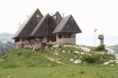
Limonetto » Rifugio Garelli
|
7h30 |
26.51 km
|
1732 m
|
1069 m
This stage is of historical interest and affords truly spectacular views. The Tenda pass has a number of fortifications and from there the trail continues on the ridge with panoramic views. The route follows the Carsene valley, an important Karst area in the Alta Valle Pesio and Tanaro nature park. It goes over the Duca pass and down into the Marguareis valley to the Garelli hut. This leg is partially practicable by mountain bike, too from Limoneto to Capanna Morgantini. Otherwise: R149 + R150 as a variant: from Morgantini continue up to Don Barbera Refuge and from here go down to Carnino – or continue along the Limone-Ventimiglia road until Melosa.
From the Tende pass, walk to the left on the wide track that climbs to the east and leads to the Central fort, which can be seen from the pass, following the red and white markings of the GR® 52A. Circumvent the buildings on the right to arrive at the parvis of the fort. Continue to the east on the track that circumvents a fortified hill to the north and descends towards a pass without a name. Continue along the track branching off to the right for a few metres to reach this pass (marker 338). Leave the track and take the path marked in yellow that climbs eastward over the brow of a hill and runs along the border. Below the peak of the Bec Roux, the path once again joins a track, still running alongside the borderline. The track descends slightly with a few hairpin bends before dividing into two. Stay on the track that runs along the border on the north slope of a little summit without a name (2,336m). The track circumvents the Bec summit on the south side and then heads north to reach the Perle pass (2,086m), where it joins three other road sections. Take the path marked in yellow that sets out along a ridge in a north north-easterly direction to climb a little summit without a name (2201 m) and head down again to the Boaïra pass (2,102m). Leave the track and the path marked in yellow on the right which are heading eastward and also another path marked in yellow that descends into the monoclinal valley on the Italian side. Take the middle path which leaves on virtually a level course towards the north and winds its way above the track alongside the borderline. This path is not marked. About 2km further and just before it turns to the east, leave the path and climb to the north on a gentle slope for about thirty metres to arrive at Colle Plane (borderline). (Paul Guglielmi, CDRP 06)
Favourites, criticisms ? Make your personal comments on this stage. For more general notes please use the comments section of the page Over to the Via Alpinists.
Traue nicht den Zeitangaben auf den Wegweisern, denn zweimal sind die Marschzeiten zum Rifugio Garelli massiv falsch beschriftet (anscheinend schon seit Jahren). Wer in Limonetto im Posto Tappa L'Abric übernachtet, kann sich vom Gastgeber nach dem Frühstück gegen eine Gebühr zum Colle di Tenda hinauf fahren lassen. Das verkürzt diese sehr lange Tagesetappe um zwei Stunden, was bei Abendgewittern sehr nützlich sein kann. Beim Colle della Boaria besser auf den direkteren und schöneren Wanderweg zur Capanna Morgantini abzweigen, statt auf der Militärstrasse zu bleiben.
You must do this very long trip in one go! The only seemingly alternative is Cabana de Morgantini. But this small hut was closed, with windows and doors shut.
Henk - 2019-07-26
Limonetto is a depressing ghost village. There is one small bar and one tiny shop. When leaving the village, follow the GTA / L14 signs, and not the gpx-track from the website, which needlessly deverts you over tarmac and along ski installations. When you arrive at the border with France, the Via-Alpina track suggests taking the military road Monesi - Col di Tenda. This is terrible because on some days motorized traffic is allowed here and attracts bikers and 4-wheel suv's. Better take the path above the road: shorter, better views. It is marked "GTA". There are virtually no "Via-Alpina"signs in the field.
Berta - 2018-08-25
Der GPS Track zeigt den Weg zwischen Colle di Tenda und ca. Gias dell' Ortica auf der Schotterstraße, es gibt aber einen wznderschönen Wanderweg, teils am Kamm, teils am Hang laufend. Rigugio Garelli ist gut geführt, schöne Lager mit reichlich Platz, Essen und Frühstück ok. Lager mit Halbpension f Club Alpin Mitglieder 38€
Automatic translation
[Google]
The GPS track shows the way between Colle di Tenda and about Gias dell 'Ortica on the gravel road, but there is a beautiful hiking trail, partly on the ridge, partly on the slope running. Rigugio Garelli is well run, nice camp with plenty of space, food and breakfast ok. Camp with half board f Club Alpin members 38 €
Elisabeth - 2016-11-18
Il y a quand même deux points d'eau (cabane Morgantini et Gias dell'Ortica) + le torrent émissaire du lac du Marguareis. Selon moi il faut compter plutôt 10 h !
Automatic translation
[Google]
There are still two water points (Cabin Morgantini and Gias dell'Ortica) + the torrent of Lake Marguareis. I think it takes 10 hours!
Il faut partir tôt de Limonetto, très belle étape, mais assez longue, souvent par sentier en balcon. J'ai mis 8h30 sans pause.
Automatic translation
[Google]
We must start early Limonetto, beautiful stage, but quite long, often trail balcony. I put 8:30 without a break.
Jean-Louis GIRAUD - 2013-05-20
Ne pas hésiter à emporter une bone provision d'eau pour cette longue étape ...Pas de sources sur ces plateaux et reliefs karstiques .
Coordonnées du Refuge Piero GARELLI :
Tel 00 39 (0)171 738078
Tel Cell 3397709937
Email : mccoulomb@tiscalinet.it
Automatic translation
[Google]
Do not hesitate to take a bone supply of water for this long stage ... No sources of these plateaus and karst. Contact Refuge Piero GARELLI: Tel 00 39 (0) 171 738078 Tel Cell 3397709937 Email: mccoulomb@tiscalinet.it
Jean-Louis GIRAUD - 2013-05-19
Longue mais magnifique étape dans un environnement desert et sauvage. l faut compter 8 / 9 h...et non 4 h comme noté sur le topo pour parcourir ces chemins de cretes puis rejoindre le refuge GARELLI aprés une dernière remontée dans le vallon du Marguareis .
J'ai particulièrement apprécié...
Excellent accueil au refuge, wifi, douche chaude et repas de grande qualité.
A noter une erreur significative concernant de temps de marche sur la signalétique du Gias dell'Ortica...
Automatic translation
[Google]
Long but wonderful step in a desert and wilderness. takes the 8/9 pm ... and not 4 pm as noted on the deal to go through these paths and ridges reach the refuge GARELLI after the last lift in the valley of Marguareis. I especially liked ... Excellent home at the shelter, wifi, hot shower and meal quality. Note a significant error of running time on the details of Gias dell'Ortica ...
Die Angaben zum Rifugio Garelli stimmen nur teilweise: 1. Die Hütte gehört dem Club Alpino Italiano (CAI, Sez. Modovì) und gewährt somit im Rahmen des Kooperationsabkommens Mitgliedern anderer Alpenvereine Ermaessigungen.
2. die Hütte ist nicht mit dem PKW anfahrbar.
Automatic translation
[Google]
The information on Rifugio Garelli are only partly: 1 The lodge is owned by the Italian Alpine Club (CAI Sez Modovì) and thus granted under the Cooperation Agreement members of other Alpine Clubs Reductions.
Second the hut is not approachable by car.
Der Profilpunkt „Quota 1540 m“ zwischen Colle di Tenda und Colle Perla ist verkehrt. Stattdessen ist der Wegverlauf leicht ansteigend bis auf circa 2.200 m mit nachfolgendem kurzem Abstieg zum Colle Perla.
Automatic translation
[Google]
The profile option "quota 1540 m" between Colle di Tenda and Colle Perla's wrong. Instead, the Route is slightly increasing up to about 2,200 m followed by a short descent to the Colle Perla.

 |
7h30 |
26.51 km
|
1732 m
|
1069 m
|
7h30 |
26.51 km
|
1732 m
|
1069 m


Favourites, criticisms ? Make your personal comments on this stage. For more general notes please use the comments section of the page Over to the Via Alpinists.