Hiking (mountain trail, in places narrow and exposed)
Alpine route (equipped or very exposed section, snow field, blocks)
R131
Mont-Dauphin (Guillestre) » Refuge de Furfande
|
5h45 |
17.5 km
|
1492 m
|
240 m
Just after Mont-Dauphin, Via Alpina crosses the village of Eygliers and joins the GR® 541 heading to the Queyras regional nature park. After having passed the highest point at the Garnier pass, the trail descends again to the Furfande hut in the midst of the pastureland by the same name, also situated on the GR® 58 “Tour du Queyras” trail.
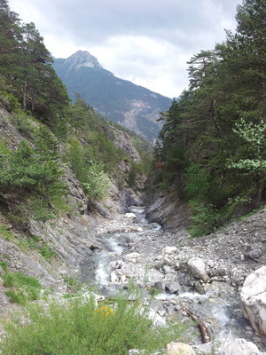
Leave Mont-Dauphin to the north on departmental road D137 and then follow the D 37 as far as the village of Eygliers. Cross the village, after which the D 371 leads to a crossing with the GR® 541, which arrives from the left from the hamlet of Coin. Continue on the D 371, on a ledge, to the hamlet of Gros, which is left behind on the right. Follow the road paved in stone to reach the so-called "Deuxième Batterie". Continue the climb and then take a path leading downhill to the bottom of the Valette ravine, cross the footbridge and climb back up on the opposite trail into the forest to reach the ruins of the Girards shepherds’ huts (1,670m). Continue towards the north west to reach the forest, leaving the right-hand trail behind. At the next fork in the road, turn left and then right and head uphill into the forest. Cross a barren hilltop and then veer to the right, pass a little spring, cross several little streams heading uphill before reaching the Garnier pass (2,279m). From the pass, descend northward and then along the axis of the little valley, passing a spring and crossing several small ravines, leaving the trail descending from the Saint Antoine pass on the left and the Valette lake. Veer to the right, pass a wayside shrine and then continue on the left-hand path, which climbs in a long bend to the left to the Furfande pass (2,500m), past which the GR® 58 runs. Descend towards the south to reach the Furfande hut (2,300m). (Marc Buisson, CDRP 05)
Natural and cultural heritage
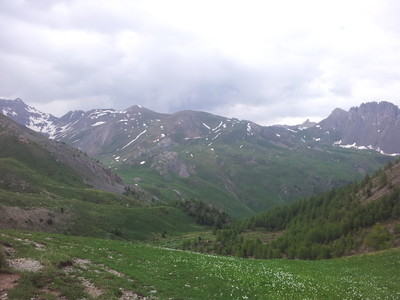
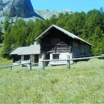
The trail leaves the Durance valley and joins the Queyras regional park, which since 1977 has pooled the efforts of the 8 communities around the will to achieve environmentally friendly development. East of Montdauphin, Eygliers comes into sight, a summer hamlet for the valley dwellers. The church of St Antoine, an archetype of XVIth century Lombard-Romanesque style, adorns the heart of the village and with its many frescoes reminds everyone of the legend of the pilgrims of Santiago de Compostela: a young man is wrongly accused of theft by the maidservant of a hostel whose advances he has refused. He was hanged, to the great despair of his parents, who spent the rest of their journey praying. On their return, they found that their son had been brought back to life and avenged. An old Roman road links Font-d’Eyglier to the main town and allows us imagine the route taken by the Roman troops leaving to conquer Italy. The villages and communication posts at the time were established on mountain ridges in order to avoid water damage and to benefit from “strategic” panoramic vision. For instance, visible further below and cut in two by the waters of the Guil in the fossil moraine of the Durance glacier, the Guillestre plateau, formerly “of the thousand winds”, is occupied on the left bank by the homonymous village, and on the right bank by the fort of Mt Dauphin. There have been several attempts in the area to grow vineyards under the ownership of the inhabitants of Ceillac or Vars and irrigated using various tapped springs. But altitude put an end to such ambitions. Just after this comes the start of the sheer Guil gorges, over which the trail hangs for a while on the north side of the Roy house, thus named because of its strategic position and a recorded visit by Louis XII. The trail now pushes more boldly into the heart of the Sufra woods, a mix of larch and pine, to then cross the Garnier pass, an unusually broad, grassy pass marking the traditional border between Eygliers and Arvieux (from the Latin arvum = labour), and thus a source of recurring conflict over the ownership of this stretch of pastureland. A little below this, the chalets of Furfande perpetuate the agricultural tradition of the Queyras region (pasture festival on the 1st Sunday following 15th August). This is where the pastoral life of the Arvidants (inhabitants of Arvieux) was for a long time based on livestock farming (Tarentaise cows, of a uniform faun colour, and Abondance cows, mahogany with a white head), from production (breeding and haymaking) to processing and then sales. This exceptionally flowery meadowland is still a mountain pasture location in June. And the Arvieux cheese dairy is still famous for its Queyras specialities. The Furfande Hut, a former alpine farm chalet itself, is established at the foot of the pass by the same name, which serves as a donkey pass between the Guil valley and the Arvieux basin. The easily recognisable Ratier tooth rises up towards the East and the Croseras ridge offers protection from the winds above. (Sara Zeidler, Gilles Chappaz, Grande Traversée des Alpes)
Favourites, criticisms ? Make your personal comments on this stage. For more general notes please use the comments section of the page Over to the Via Alpinists.
Berta - 2018-08-14
Das Refuge Furfande ist eine sehr gut geführte Hütte, sehr freundliche Leute und sehr gutes Essen. Auch die Lage ist wunderbar, bei schönem Wetter kann man herrlich vor der Hütte sitzen und das unglaubliche Panorama genießen. Besser reservieren +33 616562379. Lager mit Halbpension f 50 € pro Person
Automatic translation
[Google]
The Refuge Furfande is a very well run cottage, very friendly people and very good food. The location is wonderful, in good weather you can sit in front of the hut and enjoy the incredible panorama. Book better +33 616562379. Camp with half board f 50 € per person
michel Parapluie - 2016-06-14
4h20 est un temps nettement sous-estimé. comptez 1 heure de plus minimum
Automatic translation
[Google]
4:20 ET time significantly underestimated. allow 1 hour longer minimum
Elisabeth - 2015-10-14
Plus de passerelle sur le torrent de La Valette (entre Gros et les Girards)
Automatic translation
[Google]
More footbridge over the brook Valletta (between Gros and Girards)
Elisabeth - 2015-10-14
La description passe rapidement sur la montée à Gros. C'est quand même 1h45 de montée sur une petite route étroite le long d'une paroi rocheuse plein sud : éviter de la faire en plein cagnard !
On ne passe pas au col de Furfande, contrairement à ce que laisse supposer le descriptif.
Automatic translation
[Google]
The description goes on quickly rising in Gros. It's still 1:45 mounted on a narrow road along a southern rock face: to avoid the full dodger! You can not pass the neck of Furfande, contrary to what the description suggests.
tof - 2015-05-15
Trieste-Monaco le 5/10/2014
Furfande est fermé en cette période. Variante pour rejoindre directement Ceillac. Par la piste forestière de la forêt de la Réortie. Si motivé remonter pour raccrocher le chemin qui suit le Cristillan en rive gauche. Sinon descendre sur "l'Ubac d'aval" puis un peu de route avant de trouver un sentier qui amène à Ceillac.
Etape à Ceillac, au gîte "le matefaim". Appeler bien à l'avance car fermé en cette période. Chambre avec plaque électrique. Petit-déjeuner servi par le gîte. Bon accueil et présent en cas de besoin.
/!\ Attention, en cette période plus de ravitaillement ni hébergement possibles après Guillestre jusqu'à l'Italie (Campo base). La désertification des services est bien ancrée...
Automatic translation
[Google]
Trieste-Monaco on 05/10/2014 Furfande is closed during this period. Variant for direct access Ceillac. For the forest track forest of Réortie. If motivated to hang up the road that follows the left bank Cristillan. Otherwise get off on "downstream Ubac" then a little road before finding a path that leads to Ceillac. Step Ceillac, the lodging "the Matefaim". Call well in advance as closed in this period. Room with electric hob. Breakfast served by the cottage. Welcome and present when needed. /! \ Attention in this period more than refueling or possible accommodation after Guillestre to Italy (Campo base). Desertification services is well established ...
2h to reach Col Garnier from refuge de Furfande, then 4h going a lot down to reached Mont Dauphin
it is possible and i think better to catch up the GR5 in the Queyras regional park radther than taking the option I did following the Via Alpina
Mont Dauphin has a gite le glacier Bleu, very friendly hosts (Laure and Olivier), paid 16,5euros for private 2 beds room, very clean room
Did not ate dinner but think it really worth eating @ le glacier bleu. Highly recommanded to stay there. Another concept
of hosting here. Own by friendly persons. Been given a fresh baguette on my departure from le Glacier bleu...
Ceillac – Mont Dauphin : 8h30 walking, 2h30 resting, 36,9km

 |
5h45 |
17.5 km
|
1492 m
|
240 m
|
5h45 |
17.5 km
|
1492 m
|
240 m


Favourites, criticisms ? Make your personal comments on this stage. For more general notes please use the comments section of the page Over to the Via Alpinists.