Hiking (mountain trail, in places narrow and exposed)
Alpine route (equipped or very exposed section, snow field, blocks)
R127
Névache » Le Monêtier-les-Bains
|
4h12 |
12 km
|
832 m
|
956 m
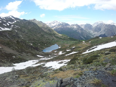
This stage leaves Névache for the Buffère chalets, then swings into the Guisane valley via the Buffère pass, which offers a panoramic view over the Ecrins massif. Further below, the trail leaves the GR® 57 to descend directly to Monêtier-les-Bains, the stage destination and thermal resort dating back to Roman times.
In the village of Névache, find the GR® 57 again near the church, take the street to the left, cross the Clarée valley on the Outre bridge and head back up the right-hand bank, leaving behind the trail that branches off to the left towards Porte de Cristol. Walk across an outcrop facing the Lacou waterfalls, and pass several streams including the Buffère stream before arriving at the Rately bridge (1,749m). Do not cross it, instead slanting across to the left to reach the larch wood, entering it on an uphill trail. Leave the right-hand trail that climbs the valley behind to arrive at the Serre chalets. Continue to climb along the sometimes steep trail to reach the Buffère chalets (2,075m), ignoring the left-hand trail that heads to the little Cristol valley. Continue in an upstream direction through the valley, including a short rocky passage, and after circumventing a marshy zone, you arrive at the Buffère pass (2,427m). Take the stony downhill trail on the other side towards the south west to reach the Chemin du Roy trail at an altitude of 2320m, which must be followed to the right as far as the meeting point (2,203m) of the GR® 57 meets the GR® 50. Continue more or less cross-ways on the Chemin du Roy trail for about 2km. At the next crossroads, leave the GR® 57 which climbs up the little Moulette valley and continue on the GR® 50 for a short distance to reach the Moulette spring. Leave the GR® 50 behind to descend along the left-hand trail and reach the forest, and after a few hairpin bends and the reservoirs, take a little road that leads to Monêtier-les-Bains. (Marc Buisson, CDRP 05)
Natural and cultural heritage
On leaving Névache at Ville Haute and until the Rately bridge, walk alongside the Clarée river on the right-hand bank, where the ground is populated by martagon lilies. Next, climb via the Buffère chalets to the pass of the same name (2,427m), marking the entry to the Guisane valley and offering the first panoramic view of the Ecrins. Head uphill to a little rocky promontory to the left of the pass, from where it is possible to see the highest summit, the Barre des Ecrins (4,102m). The pleasant descent along the GR® 57 trail, circling above the Guisane valley, passes through meadowland in which the potentilla delphinensis (“potentille du Dauphiné”) grows, a rather rare plant that can nevertheless be seen around Puy Jaumar. In the surrounding area, you may also spot the Tengmalm’s Owl. After walking close by the Moulette springs that supply water to Monêtier-les-Bains, the trail zigzags its way to the doors of the village through the newly planted forest of St Joseph, the reforestation of which was carried out within the framework of the RTM restoration of mountain terrain project in a bid to combat the dangerously intense erosion process (floods). In Monêtier-les-Bains, the presence of the larch forest becomes even more noticeable in the very architecture: each house has a polished larch balcony, rendered even more beautiful by the sun, which in Guisane is particularly fierce. The village has a rich past owing to its function as a stop-off point on the “little road” of the Lautaret pass connecting Grenoble and Briançon. In fact, it has gained in both pecuniary and cultural terms from its contact with the travellers and tradesmen passing through. But Monêtier’s hour of glory was at the time of the spa treatments organised in the Roman era when the village was still called Sanatio –(“healing”) and which continued until the start of the century. Today, the rotunda built in the XVIIIth century still stands, and the hot springs are once again starting to be used for spas, and even for more touristic purposes (municipal project for a “thermo-leisure” centre). Monêtier was also a Mecca of religious fervour, and the relics of various chapels in the market town (furniture and liturgical ornament collections) can now be admired in the Museum of sacred art in the chapel of St Pierre, which used to be part of the White Penitents confraternity and keeps a collection of the religious treasures of the 30 chapels. Briançon, situated further down the Guisane valley, is the “highest town in Europe” (1,200m). What is more, it boasts an impressive series of fortifications totally adapted to the mountain setting and designed by Vauban to protect the town in 1692. (Nicolas Aubertin, Gilles Chappaz, Grande Traversée des Alpes)
Favourites, criticisms ? Make your personal comments on this stage. For more general notes please use the comments section of the page Over to the Via Alpinists.
Im Abstieg nach Monêtier geben Wanderbeschreibung und Via-Alpina-Wegmarkierung verschiedene Richtungen an. Wir folgten den Wegweisern und gelangten durch den Bois de Saint Joseph gut hinunter ins Tal.
Automatic translation
[Google]
In the descent to Monêtier, the hike description and the Via Alpina trail mark different directions. We followed the signs and got through the Bois de Saint Joseph well down into the valley.
Momo - 2018-08-16
Die Beschreibung ist irreführend - man folgt dem GR 57, nicht dem GR 50! biegt man da ab, gibt es auf der Didier-Karte zwar noch einen eingezeichneten Weg über die Schlucht - wir haben den nicht gefunden.
Automatic translation
[Google]
The description is misleading - one follows the GR 57, not the GR 50! If you turn off, there is still a marked path over the gorge on the Didier map - we did not find it.
Berta - 2018-08-02
Wir haben in Monetier über booking.com ein Zimmer im Hotel Violaine gebucht, nettes Personal, gutes Zimmer nur vom Abendessen waren wir nicht so begeistert. Doppelzimmer ohne Frühstück 77€, FS 8€
Automatic translation
[Google]
We booked a room at Hotel Violaine in Monetier via booking.com, nice staff, good room only from the dinner we were not that thrilled. Double room without breakfast 77 €, FS 8 €
If you have a GPS (you should!) you will notice that after Col de Buffere there is an unmarked track leading straight down. The start of the track is very, very hard to find. Trust your GPS, it Will save you a detour. Nevertheless the time to get down is much more then 2 hours!
JLC - 2016-10-02
28/9/2016 Longue étape du refuge du Thabor à Monétier; peu d'hébergement disponible à Monétier, beaucoup de resto fermés; Buffère venait de fermer la veille; très bon balisage; peut-être plus rapide de descendre au Freyssinet pour rejoindre le Monétier.
Automatic translation
[Google]
28/9/2016 Long stage of the refuge of Thabor in Monétier; little accommodation available in Monétier, many restaurants closed; Buffere had just closed the day before; very good markup; perhaps faster to get off at Freyssinet to join the Monétier.
Elisabeth - 2015-10-14
Temps sous-estimés, indications de km contradictoires. J'ai été très mal reçue au refuge de Buffère, alors que je venais y déposer une paire de lunettes trouvée en chemin.
Automatic translation
[Google]
Underestimated time km of contradictory indications. I was very badly received refuge Buffère, when I had to deposit a pair of glasses found on the way.
Tof - 2015-05-01
Trieste-Monaco 29/9/14
Les chalets de Buffère ne sont pas ouverts à cette période. Ai croisé la gardienne, Bernadette, le chalet est en travaux pendant la fermeture. Chouettes échanges et bn café !
Belle ambiance de cheminement dans la montée après les chalets de Buffère, accompagné par les chants de Tétras-lyre.
Au col de Buffère, nouveau paysage: les Ecrins! Descente sur Monetier avec une végétation qui devient plus méridionale.
Monetier les Bains:dernier jour d'ouverture du camping municipal. Ouf ! En ville rien d'ouvert.
3 épiceries toutes fermées, ravitaillement impossible. Pas de bus pour rejoindre le bas de vallée. Monetier ne vit-elle que pour le ski ? Oui d'après certains locaux...
Peut-être qu'il serait plus judicieux de faire comme Thierry( post ci-dessous): de filer sur Briançon. Ce serait aussi rater Vallouise. A voir. Ne comptez pas trop sur Monetier à cette période.
Automatic translation
[Google]
Trieste-Monaco 29.09.14 Buffère The chalets are not open at this time. Came across the guardian, Bernadette, the cottage is under construction during closing. Owls and bn trade coffee! Belle ambiance path in the rise after the chalets Buffère, accompanied by the songs of Black Grouse. The neck of Buffère, new landscape: the Ecrins! Descent to Monetier with vegetation becomes more Southern. Monetier les Bains last day of opening the municipal campsite. Phew! In city open anything. 3 grocery stores all closed, not supplies. No bus to the lower valley. Monetier not she lives for skiing? Yes according to some local ... Maybe it would be better to do as Thierry (post below): spinning on Briançon. It would also miss Vallouise. To see. Do not rely too much on Monetier at that time.
Possible variante here from Nevache to Briancon.. Porte de Cristol, Col Granon et GR5C on an amazing ridge walk over 2000m, 360 panoramic view during hours
Dans la mème journée , j'ai parcouru les étapes R126 et R127 entre les Granges de la Vallée Etroite et Monétier les Bains...ou je suis arrivé un peu plus tard que prévu !
En effet, il y a certainement une erreur sur le topo qui indique 10 mn pour un dénivelé de prés de 350 m et une distance de 2 km ! Il y a également quelques surprises comme la longue traversée montante du Vallon de la Moulette !
J'ai trouvé un hébergement et un accueil sympa au gite LE FLOUROU 31 rue Bongourget
Tel 00 33 (0)4 92 24 41 13
flourou@cegetel.net
Excellent repas.
Automatic translation
[Google]
In the meme day I walked the steps R126 and R127 between Granges Valley Narrow and Monétier les Bains ... and I arrived a little later than expected! Indeed, there certainly has an error on the topo which indicates 10 minutes to a height difference of 350 m and a distance of nearly 2 km! There are also a few surprises like the long ascending crossing the Valley of the Moulette! I found an accommodation and a friendly welcome at the cottage THE Flourou 31 rue Bongourget Tel 00 33 (0) 4 92 24 41 13 flourou@cegetel.net Excellent meal.
Tippel - 2012-08-05
From Névache nice shady walk beside creek, after that pretty uphill hiking to Chalets de Buffère. They served lunch outside: Food is really a highlight, service charming - we should have spent the night here!! Many beautiful sights till you get to Col de Buffére.
Chalets de Buffère was one of the best places where I spent a night on the via alpina. They have free hot shower, free internet (year 2010) and amazing, really amazing good food!
Please send them my best wishes!!!

 |
4h12 |
12 km
|
832 m
|
956 m
|
4h12 |
12 km
|
832 m
|
956 m


Favourites, criticisms ? Make your personal comments on this stage. For more general notes please use the comments section of the page Over to the Via Alpinists.