Hiking (mountain trail, in places narrow and exposed)
Alpine route (equipped or very exposed section, snow field, blocks)
R57
Gafadurahütte » Sücka
Trail crossing
|
4h15 |
12.6 km
|
942 m
|
963 m
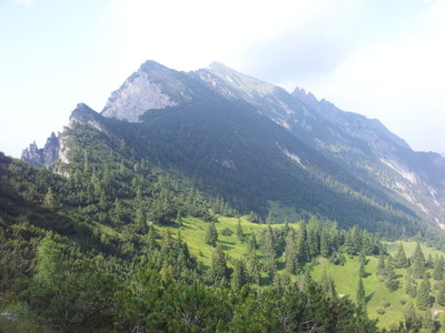
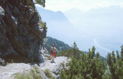
This is a classic mountain tour for hikers who are sure of foot, between the secured rocky tracks, which will never be forgotten. The outstanding view of the Rätikon range and over to the Swiss and Vorarlberg mountains and the view down into the villages, along the Rhine to Lake Constance, not to mention the magnificent rock flora, are breathtaking.
Easier alternative route (difficulty )
The Fürstensteig track can be circumvented by taking the hiking trail via Bargella (1,742m) - Helwang (1,937m).
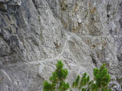
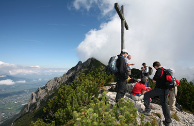
The starting point for the stage is the Gafadura Hut. Prince Johann II built it to be a hunting lodge. In 1968, the Liechtenstein Alpine Club was able to purchase the hunting lodge and its inventory and it was then converted over time into a modern mountain hut. The hike starts with a short climb to the Saroyasattel pass where the national border between Liechtenstein and Austria is crossed. Via Alpina runs around the Three Sisters to the Garsella-Alp. For mountaineers who are sure of foot and do not suffer from vertigo, it is also possible to take the hiking route over the Three Sisters. The Three Sisters track is well secured with ropes and ladders. But back to the Garsella-Alp, where the climb over verdant alpine pastures to the Garsellikopf peak begins. The Garsellikopf peak and the rest of the route offer a fantastic view into the Rheintal valley. Villages of both Liechtenstein and Switzerland lie at the feet of the hiker, divided by the Rhine. A marvellous insight into the alpine world of Liechtenstein, Switzerland and Austria is also gained here. The Saminatal valley with the Garselli/Zigerberg forest reserve lies to the east, where the aim is to preserve the woodland ecosystem, species diversity and gene pools. The development of the forest reserve is left to the course of nature, and is not exploited in any way. The Gafleisattel pass marks the start of the Fürstensteig track, which was opened in 1898. This bold and wonderfully structured track is well secured with ropes, although you do need to be free of vertigo. Those who are not should opt for the Helawang – Bargella mountain trail and then come back onto the original route once above Gaflei. A well built alpine trail above Gaflei, accompanied by magnificent alpine flora, leads via Silum to Sücka, the stage destination. The entire route is well signposted and marked in red-white-red as a mountain trail. (Ewald Oehry, AWNL)
Natural and cultural heritage
Alp Gafadura with the Alpine Club Hut belongs to the Liechtenstein community of Planken, where the Valsers settled in around 1300 on a sunny terrace over the Rheintal valley. But the name “Gafadura” bears witness to earlier land clearance in Roman times. The Swiss marched to battle in Frastanz via the Saroya-Sattel pass during the Swabian war on 20 April 1499. This crossing was also fought over in 1799 in the French war. The legend of the “Three Sisters”: three proud, hardhearted girls were gathering berries on the Holy Day of our Lady. They came across a beautiful women who asked them for some fruit for her poor sick child. “Those who want berries must gather them themselves, beggar!”, was the pert reply. The Holy Virgin then appeared as if surrounded by celestial light and said: “You have defiled my holy day, you have denied my request, you have stones for hearts. And as stones shall you stand here for all eternity”. The Three-Sisters-Trail leads from the Saroya-Sattel pass via the Garsella Alp of Frastanz to the most striking rock formations of the Three Sisters and on to the Garsellikopf peak and Kuhgrat ridge, the highest point (2,123m above sea level). This panoramic track was built in 1897 by the German and Austrian Alpine Club. Engineer Carl Schädler of the Gaflei alpine spa house took responsibility for the sections from the Kuhgrat ridge to the Gafleisattel pass. In 1898, the most daring section of the route, 1,000m high over the Rheintal valley was constructed by Prince Johann the Good. The Fürstensteig trail crosses the eroding dolomite rocks of the gypsum mountain faces of the alpine peak. Seen from a distance, the steep rocks of the Three Sisters chain appear to be bare and bleak, but the attentive hiker will notice a burgeoning plant life of algae, moss and lichen on rocky walls, blue-green round-leaved saxifrage and common moonwort, snow willow and alpine roses, auricula and field gentian, Italian bellflowers and orchids, to name but a few species. On Alp Bargella, a moraine area, the main dolomite of the Three Sisters chain is left behind. On the side of the Saminatal valley lies a huge erratic block with the inscription: “Centre of Liechtenstein. Bargälla 1,721m. World Mathematical Year 2000.” The beautifully situated village of Silum was populated 700 years ago by Valser immigrants. Today, it is the location of “Maiensäss” traditional farmhouses and an idyllic holiday destination, occupied and farmed between 1934 and 1938 by the “alpine brotherhood” religious community. On the side of the Rheintal valley, the Partnach grey-black shale and dense limestone layers can be seen along the trail. Near the Saminatal valley, a view over the impressive alpine world of Liechtenstein with the Rätikon can be enjoyed and soon the southward route reaches the stage destination, Sücka spa house below the Old Tunnel. (Johann Oehry / Ewald Oehry, AWNL)
Useful topographic maps
Wanderkarte Liechtenstein ~ Regierung FL / Liechtenstein Tourismus (1:25'000)
Favourites, criticisms ? Make your personal comments on this stage. For more general notes please use the comments section of the page Over to the Via Alpinists.
POPEYE GG - 2019-02-04
Mardi 3 juillet 2018
Superbe étape débutée à la Feldkircher Hütte, et reparti de Gafadura Hütte seulement à 13h30 pour cause d'orage.
De nouveau pluie jusqu'à Garselaalpe. De là, montée aisée jusqu'à Garsellikopf; mais après ça devient nettement plus aérien, le chemin suit peu ou prou les crêtes Kuegrat, Gafleispitz, et jusqu'au col Gafleisattel (1820m).
De là, vue l'heure tardive (17h), le temps incertain, le sol humide donc probablement glissant, le fait que je soit seul, je décide de passer par la variante (c'est juste en face au lieu de tourner à droite) certes beaucoup moins belle et assez pénible dans les éboulis en passant le col Chemi (1920m, N47° 08.878' E9° 33.472'), qui rejoint la Via Alpina à 1600m d'altitude à proximité de l'Alpenhotel Gaflei via le Bärgällasattel (1740m).
Bien heureux d'arriver à Sücka, vers 19h30!
D'autres préfèrent passer par les Drei Schwestern, mais là, c'est plus de l'escalade!
Automatic translation
[Google]
Tuesday, July 3, 2018 Stunning stage started at the Feldkircher Hütte, and left Gafadura Hütte only at 13:30 due to storm. Rain again to Garselaalpe. From there, easy climb to Garsellikopf; but after it becomes much more airy, the path follows more or less ridges Kuegrat, Gafleispitz, and up to Gafleisattel Pass (1820m). From there, seen the late hour (17h), the uncertain time, the wet soil so probably slippery, the fact that I'm alone, I decided to go through the variant (it's just opposite instead of turning right) ) certainly much less beautiful and quite painful in the scree passing Chemi Pass (1920m, N47 ° 08.878 'E9 ° 33.472'), which joins the Via Alpina at 1600m altitude near the Alpenhotel Gaflei via the Bärgällasattel ( 1740m). Very happy to arrive in Sücka, around 19:30! Others prefer to go through the Drei Schwestern, but there is more climbing!
This is physically a hard trip. Take plenty of water, because up there there isn't any. When I was about to die of dehydration on the Fürstensteig, a sudden rainstorm saved my live! The Gasthof Sücka also has dorms (CHF 30).
Tof - 2015-01-07
trieste-Monaco le 17/8/14
Suivi le Fürstensteig: succession de cables, echelles au début puis superbes chemins en balcon. Prévoir de l'eau car étape longue.
Par beau temps, il y a du monde. Difficile de se croiser par endroits.
Possibilité de bivouac au-dessus de Vaduz: aux ruines de Schalun avec aire de barbecue aménagée.
Automatic translation
[Google]
Trieste-Monaco on 17/08/14 Follow the Fürstensteig: series of cables, ladders early and beautiful paths balcony. Allow the water as long step. In good weather, there is in the world. Difficult to cross in places. Possibility bivouac above Vaduz: the ruins of Schalun with fitted barbecue area.
Monaco - Trieste
There are 2 ways from Vaduz to Gafadurahutte. The easiest stays low, the hard and steep Furstenweg worth going..took me 6h a on hot afternoon to reach Gafadurahutte from Vaduz
Margy - 2012-02-09
2/7/11 Choosing the right fork takes you to 3 hours of fun via ferratta over the Drei Schwestern. A highlight--very fun. The lodge at Suckra is expensive, a bit rundown, but the food is good.
Janek - 2011-07-21
There's something wrong with the time indicated to go from Garsella-Alp to Garsellikopf. It's supposed to be only 200m with 100m of ascent and it takes over 1 hours to ge there. You should look into it.

 |
4h15 |
12.6 km
|
942 m
|
963 m
|
4h15 |
12.6 km
|
942 m
|
963 m
 )
)


Favourites, criticisms ? Make your personal comments on this stage. For more general notes please use the comments section of the page Over to the Via Alpinists.