Hiking (mountain trail, in places narrow and exposed)
Alpine route (equipped or very exposed section, snow field, blocks)
R51
Oberstdorf » Mindelheimerhütte
Trail crossing
|
7h00 |
21.8 km
|
1436 m
|
254 m
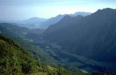
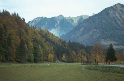
A long stage, but which starts at a very comfortable pace: from Oberstdorf southwards past the Loretto chapel to the Schiflugschanze, one of the biggest ski-jump complexes in the world. The trail only becomes steeper on reaching Birgsau and then arrives at the beautiful Guggersee lake, which reflects the surrounding mountains.
From the southern end of the village of Oberstdorf, start off along the Birgsau/Einödsbach arterial road on a comfortable hiking path passing the St. Loretto chapel and heading into the Stillachtal valley. After crossing the Stillachbrücke bridge, the trail leads to the West of the river past the famous Heini Klopfer ski jump in Oberstdorf to Faistenoy. This is where the valley station of the Fellhornbahn railway is situated. By the banks of the Stillach river, continue until reaching the little village of Birgsau. It is served regularly by an RVA bus connection (3h 20min). The narrow bridge in Birgsau is the starting point for the steep climb to the Guggersee lake. Begin by climbing up across the meadows and later through the wood. Already at an altitude of 1,400m, leave the wood behind you and follow the track after a short, somewhat flatter stretch further uphill over alpine meadows until coming to the little, crystal-clear mountain lake (approx. 2h 30min from Birgsau). The route becomes less steep and continues to the overgrown Taufersbergalpe meadowland and from there – keeping to the right – through the wide Roßgund cirque. Below the jagged ridge of the Schafalpenköpfe summits, you will reach the Mindelheimer Hut without any great changes in altitude (approx. 2h 30min). (Christina Schwann, OeAV)
Natural and cultural heritage
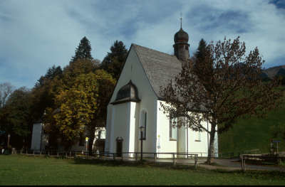
The Heini Klopfer ski jump, also called the “leaning tower of Oberstdorf”, is one of the most architecturally astonishing constructions in the Stillachtal valley. A ski jump was already built in 1949 on the initiative of the unforgettable jump trio Sepp Weiler, Heini Klopfer and Toni Brutscher. It was altered on the occasion of the 1st ski jump world championships in 1973 by Sepp Noichl. For the world elite of ski jumpers, it has since become a firm component of their competitions and also one of the four jumps on the "Four jumps tour". The longest jump distance in Oberstdorf was achieved by Norwegian Roar Ljoekelsoey with 223m in the ski jumping in 2004. The jump can be visited all year round. The Loretto chapel on Lorettostraße road is worth seeing and is situated along the trail to the Birgsau area. The pilgrimage and wedding church refers to the St. Loreto place of pilgrimage near Ancona, as both experienced the same vision of the Virgin Mary. A large picture in the church shows the pilgrims from the Lechtal valley walking over the Mädelejoch pass to Oberstdorf (corresponds to the Via Alpina Yellow Trail). (Christina Schwann, OeAV)
Other long-distance trails and alternative routes
From Faistenoy, take the Fellhornbahn lift to the Schlappoldsee station. First head along the nature theme trail in the direction of Grundsattel and continue past the Fiederpass Hut to the Mindelheimer Hut.
Nr. 3, Allgäuer Alpen, Kleinwalsertal ~ Kompass (1.50.000)
Nr. 2/1 Allgäuer - Lechtaler Alpen, West ~ Oesterreichischer Alpenverein (1:25.000)
Ök 50 113 ~ Bundesamt f. Eich- u. Vermessungswesen (1:50.000)
Picture gallery
Add your own pictures!
Comments
Favourites, criticisms ? Make your personal comments on this stage. For more general notes please use the comments section of the page Over to the Via Alpinists.
Jürgen - 2019-07-30
Im Bereich "Natur- und Kulturerbe" steht: ... die "Heini-Klopfer-Skiflugschanze"... eine der vier Schanzen der "Vier-Schanzen-Tournee"....
Dies ist falsch. Die Schattenbergschanze in Oberstdorf ist Teil der Vier-Schanzen-Tournee. Die Heini-Klopfer-Skiflugschanze ist Austragungsort für Skiflugveranstaltungen (Weltcup, Weltmeisterschaften)
Automatic translation
[Google]
In the area of "natural and cultural heritage" stands: ... the "Heini-Klopfer-Skiflugschanze" ... one of the four hills of the "Four-Hills-Tournament" .... This is wrong. The Schattenbergschanze in Oberstdorf is part of the Four Hills Tournament. The Heini-Klopfer-Skiflugschanze is the venue for ski flying events (World Cup, World Championships)
POPEYE GG - 2019-02-03
Jeudi 28 juin 2018
Belle étape, notamment depuis le petit lac Guggersee; malheureusement, une grande partie sous un temps gris voire pluvieux.
Le refuge fut le bienvenu!
Automatic translation
[Google]
Thursday, June 28, 2018 Beautiful stage, especially since the small lake Guggersee; unfortunately, much of it in gray or rainy weather. The refuge was welcome!
Die direkte Telefonnummer zur Mindelheimerhütte (R51/52) lautet +49 8378 7238.
Automatic translation
[Google]
The direct telephone number to Mindelheimerhütte (R51 / 52) is +49 8378 7238.
tof - 2014-12-27
Trieste-Monaco le 9/8/14
Longue marche à plat jusqu'à Birgsau. De là départ vers le refuge. J'ai loupé l'itinéraire via Guggersee. Ai suivi un itinéraire commun avec les vélos le long de plusieurs huttes, en fond de vallée, avant une ascension finale raide pour le refuge. Itinéraire peu intéressant.
Refuge de Mindelheimerhutte. Encore une fois des comportements de chambrée pas habitués au besoin de calme d'un refuge.
Automatic translation
[Google]
Trieste-Monaco on 08/09/14 Long walk flat until Birgsau. From there start to the refuge. I missed the route via Guggersee. Have followed a common route with bicycles along several huts in the valley, before a steep final climb to the shelter. Route unattractive. Refuge Mindelheimerhutte. Again behaviors chambered not used to need a quiet refuge.
Monaco - Trieste
Possible to take on Greisshorn peak (40min off the via alpina trail) before Mindelheimerhutte. Challenging variante trail called Mindelheimer Klettersteig possible from Mindelheimer hutte (170beds there 10euros for a bed, fast, friendly and efficient staff, home made food is served)
Trail is smooth and quite long between Mindelheimerhutte and Birgsau (took me 2h30 down)
Birgsau - Oberstdorf 2h by the road..Via Alpina goes around but hard to find trail
Possible to bypass Oberstdorf from Mindelheimerhutte to reach Kemptnerhutte and avoiding getting down very low (Oberstdorf 824m)
Margy - 2012-02-09
Took the bus to Bergsau instead of walking on the road. Mindelheimer Hutte has excellent food! Fresh pasta.

 |
7h00 |
21.8 km
|
1436 m
|
254 m
|
7h00 |
21.8 km
|
1436 m
|
254 m


Favourites, criticisms ? Make your personal comments on this stage. For more general notes please use the comments section of the page Over to the Via Alpinists.