Hiking (mountain trail, in places narrow and exposed)
Alpine route (equipped or very exposed section, snow field, blocks)
R40
Kellerjochhütte » Schwaz
|
6h05 |
15.7 km
|
614 m
|
2063 m
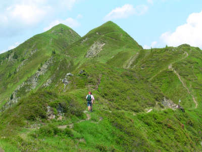
A stage offering great vantage points and ending in the silver-mining town of Schwaz lies ahead. The climb to the Kellerjoch hut is quite steep, but the cosy hut can satisfy all that a hiker’s heart could desire. Continue either via the old Alte Kellerjoch hut or following the ridge over the Kreuzjoch pass and Gratzenkopf, to arrive in the town of Schwaz, which became famous thanks to its silver mines.
From the Loassattel pass, follow the trail in the direction of the Kellerjoch Hut, i.e. back a little from the Gamsstein or Loas inn and then uphill to the left. The track leads steeply upward, at first passing through sparse mountain woods that offer a little shade, and later across alpine grassland with almrausch (alpine roses) and pines. Apart from the fact that it can be rather hot on good days, the climb offers a wonderful view over the Karwendel, the Inntal valley and also over the Sonntagsköpfel and Gilfert peaks. Just below the Kuhmöser summit, the trail becomes flatter and even runs for a while downward along the sloping flank. From here, you can already see the Kellerjoch Hut, which was built on a particularly beautiful vantage point. One last climb leads to the Kellerjoch Hut after 2h. From here, there are several possibilities for the descent: for vertigo sufferers, the descent via the Alte Kellerjoch Hut and the Proxenalm meadow can be recommended. Those who do not suffer from vertigo and are sure of foot should choose the very beautiful, picturesque “Alpinsteig” (alpine track) past the chapel. Just behind the refuge, a track secured with wire ropes leads to the chapel on the Kreuzjoch pass (approx. 30min). From there, a steep path leads downhill to the Kellerjoch pass, where you must follow the signposts for Gratzenkopf. The trail can already easily be seen from the Kellerjoch pass and leads right along the ridge. At the two following forks in the road, keep to the left each time to reach the summit cross of the Gratzenkopf after approx. 1h 30min. After the Gratzenkopf, the trail leads downhill in a left bend. At the start, it still passes over long grass (be careful in wet conditions), later narrowly winding its way through ever denser woodland until reaching the forest road coming from the Proxenalm meadow. Follow this on the right-hand side with signs pointing to “Schwaz – Zintberg – Pirchner Aste”. Several turnoffs through the wood are well marked out in red. The Pirchner Aste inn half way along the descent offers catering services and invites you in for a snack. After one last stretch through the woods, you will reach the Zintberg mountain asphalt road. Follow it around several hairpin bends to reach the silver town of Schwaz after approx. 1h 30min (from the Pirchner Aste). Even on the descent you have a good view over Schloss Freundsberg castle, which can be easily reached via a detour along the footpath. From the forest road to the Proxenalm meadow, the track branches off leftward to the Gratzenkopf. Look for the signs and be careful not to miss them. (Christina Schwann, OeAV)
Natural and cultural heritage
The horseshoe-shaped Kellerjoch mountain range is the highest elevation at the northeastern end of the Tuxer Alps. The relatively modest peaks should not be too quickly underestimated, as the 1,800m altitude difference with the Inn makes the boulder-strewn ridge an outstanding vantage point over the Inntal valley. From the Kellerjoch Hut of the Schwaz section of the Austrian Alpine Club, you can reach the little chapel at the Kellerjoch pass using a rather exposed but well secured track and enjoy a breathtaking view into the Karwendel mountains and the Inntal valley far below. Sheltered by the high mountains to the North and the somewhat lower peaks of the Tuxer Alps to the South that allow enough sunshine onto the valley floor, the Inntal valley has very favourable climate conditions. Furthermore, the warm Foen winds have a positive effect on the vegetation – if not always on those who are sensitive to weather changes. In the past, the Inntal valley was predominantly a large, marshy area, but today its appearance is mainly influenced by agriculture, industrial areas and the Inntal motorway. The descent over the Zintberg mountain already takes you to the turn-off in the footpath to "Freundsberg" Castle, whose tower houses the Schwazer “Bergbau- und Heimatmuseum” (Mining and Local History Museum). The castle is one of the symbols used to present the lower Inntal valley. The first naming ceremony dates back to the year 1128. Mining has always played an influential role in Schwaz, the "silver town", as it is also called. The economic wealth of the town in the 15th century also had an extremely positive effect in cultural terms. And although the town was almost totally destroyed by fire in the Tyrolean Freedom Wars of 1809, many of the buildings bear witness to the brilliance of days gone by even today. The "Church of our Lady” parish church, which is the biggest Gothic church in Tyrol, the Franciscan monastery with its cloister, the Fuggerhaus (a merchant family house) and the town hall are some of the most interesting buildings to visit. Famous personalities such as Hans Sachs, Paracelsus or the Emperor Maximilian in the 15th century were guests in the silver town. Even today, world-famous artists gather to meet each other in the beautiful town of the lower Inntal valley. Special mention should be made above all to the "Klangspuren-Festival" and the "Avantgarde Schwaz", which have attracted attention from far beyond the borders of Tyrol. (Christina Schwann, OeAV)
Other long-distance trails and alternative routes
Ascent of the Kuhmöser, ascent to the 2,344m Kreuzjoch pass with chapel.
Useful topographic maps
Nr. 5/3 Karwendelgebirge Ost ~ Oesterreichischer Alpenverein (1:25.000)
Favourites, criticisms ? Make your personal comments on this stage. For more general notes please use the comments section of the page Over to the Via Alpinists.
Carsten - 2022-01-10
[4] Excellent resupply in Schwaz. Start at the Stadtgalerien (just before the river, on the left, the Via Alpina passes it, with supermarket as well as DM and Muller markets, the latter two carrying their usual range of health foods). Past the train station (whose pedestrian underpass one has to use) is a Hofer/Aldi. Prices in Schwaz are about half of what they were in Sexten or Finkenberg.
Carsten - 2022-01-10
[3] About 5km before Schwaz one reaches an asphalt road and a bus stop, Pertrach (buses run almost every hour to Schwaz). The guidebook says walk the road into town. The app Maps.me shows a hiking trail that takes off in the second far (East) curve down; signposts appear 5min into the trail, but where it starts from the asphalt road there is only a sign about a "Rodelbahn"; this somewhat rough trail descends rapidly along a creek and then moves diagonally away from the creek, crosses the asphalt road, and continues as a forest trail to the
very edge of Schwaz. Another option at Pertrach is to follow the signs to "Burg Freundsberg" with a trail that seems to continue through nice old forest; the GPS waypoints for the Via Alpina lead to within 300m and 100m altitude (below) the Burg, so from the Burg it's just a matter of descending to rejoin the GPS route.
Carsten - 2022-01-10
[2] If one goes to the Kellerjochhuette, one has 3 possibilities to continue: (1) Follow the GPS waypoints, which means an about 2km slope crossing (the slope is at a 70-80 degree angle but the trail is good, albeit narrow, early on secured with c.200m of cables that aren't necessarily needed, and the slope is covered in grass and small bushes), or (2) walk around the Kellerjochhuette and find the spur trail down to the highline trail (from afar, this looked like the easiest option; it will likely provide an incentive to bypass the Gratzenkopf, or (3) continue from the hut to the chapel and continue from there to rejoin the GPS waypoints; the trail to the chapel (300-500m) may look challenging, being secured with cables in the beginning, but to judge from conversations with other hikers, could yet be easier than (1) (which I took).
Carsten - 2022-01-10
[1] Ascending towards the Kellerjochhuette from the Gamssteinhaus at the beginning of R40, after about 15 minutes signposts give two options to reach the Kellerjochhurtte: straight up, or via a highline trail ("Hochebenweg") circling around the mountain and then ascending a spur to the hut. Both are signposted with the same time (I think it was 1 3/4 hours). Unless one wants to spend the night at the hut or for some other reason wishes to go up there, the highline trail *without* final ascent (bypass the hut, since one has to descend to 550m altitude Schwaz afterwards -- why add another 500m elevation gain to what’s already a big drop?) for no real gain -- may well be preferable. Where the spur trail branches off the highline trail to go up, one can continue the highline trail and either start descending to Schwaz (on trails) or continue in order to rejoin, after a bit of ascent, the GPS waypoints of the Via Alpina to go to the Gratzenkopf (a lower peak).
Lolo - 2019-07-31
Hebergement à Schwaz à Einhorn Schaller...très bien (56€ : nuit + petit dej). Resto fermé ce jour là.
Automatic translation
[Google]
Accommodation in Schwaz in Einhorn Schaller ... very good (56 €: night + breakfast). Resto closed that day.
POPEYE GG - 2019-02-01
Dimanche 17 juin 2018
Descente aisée sur Schwaz (nous en avions fait la moitié la veille pour cause de difficulté d'hébergement!).
A Schwaz, personne à la Pension Clara; il y avait la fête du village, peut-être en est-ce la raison?
Du coup, nous avons filé jusqu'à Stanz, sur l'autre rive de l'Inn, pour nous rapprocher un peu pour l'étape suivante. Nous avons trouvé à l'Hotel Garni Appartments Kastner (130€ pour 3).
Automatic translation
[Google]
Sunday, June 17, 2018 Easy descent on Schwaz (we had done half the day before because of difficulty of accommodation!). In Schwaz, no one at Pension Clara; there was the village festival, maybe that's the reason? So, we went to Stanz, on the other side of the Inn, to get a little closer to the next stage. We found at the Hotel Garni Appartments Kastner (130 € for 3).
Gamssteinhaus was closed (on a Saturday), but it's a great camping spot. Unfortunately I couldn't do the ridge hike to the Kellerjoch Hütte, the weather was too unstable, but there is a good alternative route that goes via Proxenalm.
In Schwaz you will stay at Pension Clara, just some 100m from the stage end-point. €38 B&B. Ask anybody for the way. Or walk down to the river, and turn right 300m to the tourist office.
Elisabeth - 2012-12-24
Depuis le refuge Kellerjochhütte, la variante par le Gratzenkopf est jolie mais beaucoup plus longue.
Automatic translation
[Google]
From the refuge Kellerjochhütte, variant by Gratzenkopf is pretty but much longer.
Jean-Louis GIRAUD - 2012-03-28
Compte tenu du trés mauvais temps et des prévisions météo, je n'ai pas souhaité dormir à SCHWAZ mais plutot avancer sur la prochaine étape R41...Je me suis finalement arrété au monastère Bénédictin de St GEORGENBERG-FIECHT. Ce soir là , il y avait de la place et j'ai été trés bien accueilli .
J'ai également pris le repas du soir et le petit déjeuner dans un réfectoire de l'abbaye .
Automatic translation
[Google]
Given the very bad weather and weather forecasts, I did not want to sleep SCHWAZ but rather the next step forward on R41 ... I finally stopped at the Benedictine monastery of St-Georgenberg Fiecht. That evening, there was room and I was very well received.
I also had dinner and breakfast in the refectory of the abbey.
Von der Rastkogel oder kellerjochhütte zweiegt der "INntaler Höhenweg" Richtung Innsbruck ab, das ist eine Variante des Roten weges, über Lizumer- und Glungezerhütte zum Patscherkofel. Details unter www.glungezer.at
Automatic translation
[Google]
From the Rastkogel or Kellerjochhütte zweiegt from the "Inntaler trail" towards Innsbruck, which is a variant of the Red route, for about Lizumer and Glungezerhütte Patscherkofel. Details at www.glungezer.at

 |
6h05 |
15.7 km
|
614 m
|
2063 m
|
6h05 |
15.7 km
|
614 m
|
2063 m


Favourites, criticisms ? Make your personal comments on this stage. For more general notes please use the comments section of the page Over to the Via Alpinists.