Hiking (mountain trail, in places narrow and exposed)
Alpine route (equipped or very exposed section, snow field, blocks)
R12
Koča pri Triglavskih jezerih » Tržaška koča na Doliču
Trail crossing
|
3h05 |
7.6 km
|
646 m
|
196 m
This stage leaves the Triglav Lakes Valley behind. Although the route avoids the highest of the lakes, it only takes a short detour to visit them. A steep, rocky slope leads up to Hribarica, beyond which is a broad plateau popular with back-country skiers during winter. The valley is rich in fauna and flora.
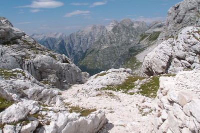
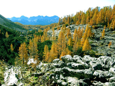
From the hut, go north up the valley. You will pass the small Močivec lake immediately after the hut, then climb up to the highlands at the foot of Tičarica. The path then levels out and becomes more comfortable, giving you a chance to look around and observe the surroundings, which are rich in Alpine flora and the increasingly rare larch tree. In front of you will be the tall peak Veliko Špičje (2,398 m), which can be reached by way of a path that branches off higher up in the valley. You will arrive at a one-time grazing area known as Pri utah below the bulging rock face of the peak Kopica (2,190 m) to the right above you. 30 minutes. At the crossroads, continue walking north and upwards through the valley. Grassy patches, larch trees and mountain pine gradually replace the rock. Walk up the gently inclining valley towards the eastern slopes until you see a large body of water in front of you. This is the lake of Veliko jezero (1,831 m), the biggest of the Triglav lakes with a maximum depth of 15 m. It is also known as Ledvička ("Little Kidney") due to its peculiar shape. 30 minutes. Continue walking along the valley until you cross a conspicuous barrier in the valley, which turns to the northeast here. The terrain here is completely bare and grey but has a small body of water, the lake of Zeleno jezero (Green Lake, 1,988 m). The lake was named after the green algae that grow at its bottom, and is host to Alpine newts and the water buttercup with its white petals. 45 minutes. The route through the Triglav Lakes Valley ends here. The path to the left leads to Zasavska koča na Prehodavcih (2,071 m). Follow the right path to the right, which gently climbs up to the gravelly glen which falls over the edge of Hribarice. Return to the pass between Poporovec to the left and Vršaki to the right by way of a series of hairpin bends. You will be standing at the edge of the spacious Hribarice plateau where the rocky terrain levels out. The path from Zelnarica will be to the right. Walk east across the plateau, which has sparse vegetation, towards the conspicuous rocky peak of Mišeljski konec. Along the way, a path branches off to the left and leads to Kanjavec. Below Mišeljski konec, you will reach the Čez hribarice pass (2,358 m) which separates it from Kanjavec. You will now be at the highest point. 50 minutes. Climb up the steep scree slope to the upper reaches of Velska valley. At the crossroads, a path branches off to the right towards Velo polje. Turn left here and follow the gently inclining path until you reach the Dolič pass (2,164 m). Immediately in front of you will be Tržaška koča na Doliču (2,151 m) and the end of the stage. 25 minutes. The hut lies on the Dolič pass between Kanjavec and the Triglav massif. The hike from Koča na Triglavskih jezerih to Tržaška koča na Doliču takes 3h. Source: Dobnik, Jože; (1998). Slovenska planinska pot. Planinski vodnik. Založba: Planinska zveza Slovenije (PZS). Mihelič, Tine; (1998). Julijske Alpe. Planinski vodnik. Ljubljana: Planinska zveza Slovenije. Atlas Slovenije (1996). 3. izpopolnjena in razširjena izdaja. Založba: Mladinska knjiga in Geodetski zavod Slovenije (GZS). Julijske Alpe - vzhodni del. (2003). 1:50.000. GZS. Ljubljana: Planinska založba PZS. Gorenjska. (1998). Izletniška karta. 1:50.000. Ljubljana: GZS. (Peter Šilak)
Natural and cultural heritage
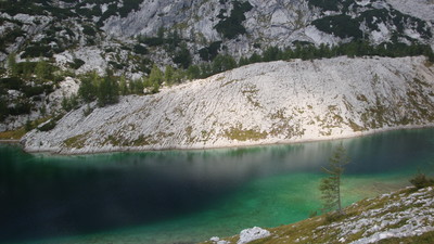
The 8 km-long Valley of the Triglav Lakes is considered the pearl of the Slovene Julian Alps. It is a glacial valley and like Komna, displays strong Karstic features. It is renowned primarily for the seven mountain lakes which were created because of the Jurassic limestone at the bottom of the valley has a lower permeability. To the east, the Valley of the Triglav Lakes is closed in by the Slatenska plošča (the Slatna Plate), which is named after the Slatna peak (2,077 m) and is composed of early Triassic limestone. The rock is covered mostly by scree, which descends the rock face of Rušnata glava (1,899 m), Velika Tičarica (2,091 m), Kopica (2,190 m), Mala Zelnarica (2,310 m) and Velika Zelnarica (2,320 m). The rocky gravel seals the cracks in the basins holding the lake waters. To the west of the valley, the limestone climbs up to Lepa Špica. There has been much disintegration of the smooth rock face over the last 10,000 years. The water has created numerous interesting gulleys and depressions in the rock. The Koča pri Triglavskih jezerih hut (1,685 m) lies north of the Dvojno jezero lake (1,669 m). These are actually two lakes whose waters combine when the water level rises in the spring, and therefore share one name. The only stream in the valley has been dammed above the hut in order to supply water. The dam has created a man-made lake known as Močivec, which is not considered as one of the seven lakes. Veliko jezero (1,830 m), also known as Jezero v Ledvicah, is the largest and deepest of the seven Triglav Lakes. It is 330 m long, 120 m wide and 15 m deep. Ledvica, a rocky protuberance on the northern end of the lake, is very picturesque. A broad patch of scree descends towards the lake from Zelnarica. Zeleno jezero (1,983 m) is the lowest of the Triglav Lakes with a depth of 3 m. There are two other small lakes in this part of the valley. At Zeleno jezero, a path leads out of the Valley of the Triglav lakes and towards Hribarica na Dolič. Rjavo jezero (2,002 m) lies in a basin near the Zasavska koča na Prehodavcih hut (2,071 m). It is 140 m long, 100 m wide and 10 m deep. The water level of the lake varies greatly during the year and the lake almost dries up completely in late summer. Jezero pod Vršacem(1,993 m) lies at the very entrance to the Valley of the Triglav Lakes. It is 95 m long, 60 m wide and 7 m deep. In late summer the lake is snowbound and frozen.
http://expo98.literal.si/slo/zakladi/vode-slovenije/triglavska-jezera.html-l2 http://www.tnp.si/s/kam/nz_podl.htm Kunaver, J. (1999). Triglavska jezera. Enciklopedija Slovenije. 13.zvezek. Ljubljana. (Jerneja Fridl)
Other long-distance trails and alternative routes
Pri Jezeru meadow, Pršivec (1,671m): From the hut at the Triglav Lakes, climb up to the Štapce pass then walk across the spectacular plateau past shepherd's huts to Koča na Planini pri Jezeru. From here, climb up to Pršivec, which provides a spectacular view of the Julian Alps in every direction, and of Lake Bohinj below. Walk across Planina Ovčarija and Štapce to the hut.
Useful topographic maps
Julijske Alpe, vzhodni del ~ Planinska zveza Slovenije (1 : 50 000)
Gorenjska ~ Geodetski zavod Slovenije (1 : 50 000)
Triglav ~ Planinska zveza Slovenije (1 : 25 000)
Useful guidebooks
Slovenska planinska pot ~ Planinska zveza Slovenije (ISBN 961-6156-11-x)
Vodnik po Julijskih Alpah ~ Planinska zveza Slovenije (ISBN 961-6156-08-x)
Vodnik po planinskih postojankah v Sloveniji ~ Planinska zveza Slovenije (ISBN 961-6156-10-1)
Websites relative to natural and cultural heritage
Favourites, criticisms ? Make your personal comments on this stage. For more general notes please use the comments section of the page Over to the Via Alpinists.
M&M - 2023-09-10
Am Plateau Hribarice unbedingt genau den Markierungen folgen. Bei Schlechtwetter und Nebel ist dieser Weg nicht zu empfehlen.
flautix - 2023-08-20
Wir starten zu dieser Etappe bei 5 Grad Außentemperatur - Rauhreif liegt auf den Wiesen! Grandiose Karstlandschaft, Gämsen, Steinböcke und Edelweiß am Weg. Die Dolicuhütte ist für uns der Tiefstpunkt sämtlicher Alpenhütten bisher: Stinkende WCs außerhalb der Hütte, ein einziges Waschbecken für alle im Flur, winzige Essensportionen und alles, was geht, wird extra berechnet. Aber durchgehend internationale Gäste - so nahe am Triglav! Die Markierungen auf dem Weg waren für uns durchgehend gut erkennbar.
Ingo - 2022-09-17
Lots of Capricorns on R12. Plus fantastic landscapes :-) No running water at all at Dolicu due to a very dry summer. Only bottled water (for sale). If there has been no rain in a long time, fill your bottles at the beginning of R12!
Bernd - 2022-09-01
Der Weg zur na Dolicu-Hütte ist sehr schön, aber nicht gut markiert und es wir hatten keinen Mobilempfang (nur GPS). Wir würden auch mehr Zeit einplanen und empfehlen in der Saison Reservierung. Wegen Trockenheit gab es keinerlei fließendes Wasser auf der Hütte, nur aus teuren Flaschen.
Carsten - 2022-01-10
R12 (mis-posted under R11)
Beautiful scenery.
No water (possibly from lakes).
Camping: no good sites and possibly prohibited.
On 6 July 2021, snow in the final ascent, near-full snow cover on the slightly ascending plateau at the top (easy traverse), dangerous descent near-completely on snow to hut at end of R12. Recommend not to do R12 under such conditions (takes significantly more concentration than R10A, and perhaps luck). Was possible only due to high temperatures with soft snow in the afternoon, and a good number of people walking R12 in reverse (easier in snow) and creating sufficient tread. Snow continued for about 1km into R13, with equally dangerous passages.
Eric van der Vlist - 2019-07-22
L'adresse mail de l'hébergement est maintenant koca.na.dolicu-at-gmail.com
Automatic translation
[Google]
The email address of the accommodation is now koca.na.dolicu-at-gmail.com
POPEYE GG - 2018-06-13
18 juin 2017
Une étape assez longue pour moi, car je l'ai prolongée jusqu'à Trenta de la R13: en effet, le refuge Trzaska Koca na Dolicu n'ouvrira que dans 2 jours.
Etape encore une fois superbe; il y a encore des névés à traverser, et même un peu sur le large chemin descendant sur Trenta.
Voir aussi mon blog "vivelaretraitesurlaviaalpina.blogspot.com".
Logement à Trenta trouvé grâce à l'office de tourisme; ravitaillement possible.
Automatic translation
[Google]
June 18, 2017 A long enough stage for me, because I extended it until Trenta of the R13: in fact, the Trzaska Koca na Dolicu refuge will open only in 2 days. Step again superb; there are still snowfields to cross, and even a little on the broad path descending on Trenta. See also my blog "vivelaretraitesurlaviaalpina.blogspot.com". Accommodation in Trenta found thanks to the tourist office; refueling possible.
From Trenta I went to Koča Sasavska instead of Doliču. This is a great hiking trail. From there I went further to Koča pri Triglavskih jezerih, so basically I skipped this stage, but it's a nice alternative..
delbende - 2016-11-02
En octobre il y avait de la neige qui masquait les marques du parcours (dernière partie un peu raide parfois) intéret d'un GPS.
Bruno et Véronique 10/2016
Automatic translation
[Google]
In October there was snow that masked the marks of the course (last part a little steep sometimes) interest of a GPS. Bruno and Véronique 10/2016
Tof - 2014-06-27
Dolicu fermé le 24/06. Accès périlleux au vu de la neige. Stop à Prehodavci et descente sur Trenta. Encore de nombreux névés sur barres rocheuses. Gardien de Prehodavci très sympa et de bon conseil.
Automatic translation
[Google]
Dolicu closed 6.24. Access perilous seen snow. Stop Prehodavci and descent Trenta. Still many snowfields on rocky ridges. Guard Prehodavci very friendly and good advice.
The Refuge Dolicu is in normal business (!), but has relatively few places. The friendly warden at the Refuge Jezerin will phone Dolicu to book your reservation!
Behind the Jezerin Refuge there is a little water-well, the only one until Trenta! Fill up well! In Dolicu there was no streaming water at all, not even a little to wash yourself! A 1,5 liter bottle will cost 4 euro.
robert - 2011-07-11
En raison du mauvais temps et de l'enneigement on nous a conseillés de passer par le refuge Prehodavcih .De là un bon chemin descend vers Cez Dol et la Zadnjica puis Trenta
Automatic translation
[Google]
Due to the bad weather and snow we were advised to go through the refuge Prehodavcih. Thence a good path down to Cez Dol and then Zadnjica Trenta
vohi - 2010-09-01
R11 - R13 können evtl. zusammen absolviert werden...
Automatic translation
[Google]
R11 - R13 can be taken together may ...
vohi - 2010-08-29
seen sind relativ warm (gilt für ende august) und laden zu kurzem Badeerfrischungsvergnügen ein...
Automatic translation
[Google]
lakes are relatively warm (this applies to the end of August) and load recently bath refreshment pleasure a ...
gonzom - 2010-08-12
"bed", not "bad" of course! :)))
gonzom - 2010-08-12
Koca na Dolicu is reconstructed and gives bad. I was drinking hot tea with lemon there two weeks ago.

 |
3h05 |
7.6 km
|
646 m
|
196 m
|
3h05 |
7.6 km
|
646 m
|
196 m


Favourites, criticisms ? Make your personal comments on this stage. For more general notes please use the comments section of the page Over to the Via Alpinists.