Hiking (mountain trail, in places narrow and exposed)
Alpine route (equipped or very exposed section, snow field, blocks)
D35
Refuge du Petit Mont Cenis » Rifugio Vaccarone
|
3h35 |
11.6 km
|
1190 m
|
566 m
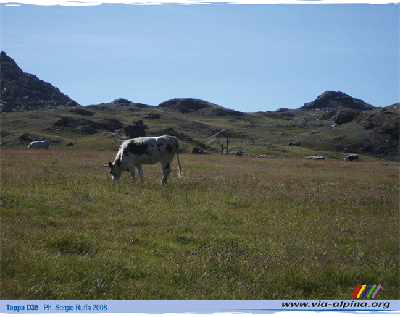
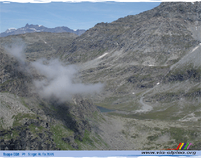
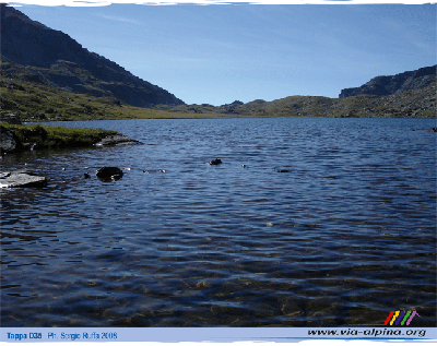
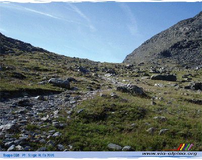
Just after leaving the Petit Mont-Cenis hut, the trail crosses the pass by the same name and then turns off towards the Savine valley, formerly a traditional route of passage and now a protected zone (Natura 2000). It continues alongside the Savine lake to reach the Clapier pass, which leads into Italy and down to the Vaccarone hut along scenic but technically, slightly more difficult trails. This leg is partially practicable by mountain bike, too up to Col Clapier.
Easier alternative route
Trails from the Clapier Lakes to the top, towards Vaccarone are equipped with guide ropes at some points.
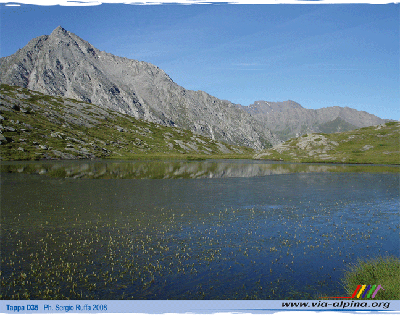
From the Petit Mont Cenis mountain hut (Piccolo Moncenisio), take the path leading to the Petit Mont Cenis peak. From the peak continue along the wide forest road which firstly goes up and then follows the contour line until a stretch of water. Reach the ruins at Granges de Savine and climb up a slight slope till the Savine lake. Skirt the lake, cross a big meadow and reach the Col Clapier or Savine’s (2477 metres), opening onto the Italian versant, thanks to a short ascent. (Jean-Luc Galland, CDRP 73)
From the Piccolo Moncenisio hut, follow the signs for the Alta Via della Val di Susa trail to the Piccolo Moncenisio pass and continue along a track to Granges de Savine. The trail is clear, along the Savine valley, climbing gently to Lake Savine. It is a busy trail. Beyond the lake the landscape becomes harsher and the trail steeper, but it is not far to the Clapier pass where it is possible to make out the ruins of military fortifications. The descent on the Italian side of the border is trickier. The marked trail runs alongside the stream to the lakes at Clapier. It then becomes steeper and more difficult to negotiate, with one stretch kitted out with guide ropes. The trail reaches a ridge and is then flat all the way to the Vaccarone hut. (Regione Piemonte)
Natural and cultural heritage
On leaving the Petit Mont-Cenis Hut, your attention will be drawn to the right by the Sollières pass separating Mount Froid (2,822m) with its old fort and the Signal du Petit Mont-Cenis (3,162m) overlooking the lake to the West. Not far from there, Via Alpina crosses the Petit Mont-Cenis pass (2,183m) and opens out opposite the Roche d’Etache (3,088m) into the little Ambin valley at the intersection with the Etache valley. But the trail immediately turns left and continues along the mountainside over rock slabs planed down by the glaciers before entering the Savine valley. This secluded little valley, more than 4km in length, benefits from special protection in the form of a biotope preservation decree, due to its high ecological interest. In fact, the decree concerns a substantial part of the Mont-Cenis plateau, as the site, which is well-known to botanists, is exceptionally rich in rare species. Its remarkable habitats are recognised under Natura 2000 for certain species of sedge or the yellow soapwort, which is only present in France in this area. During the walk down to the valley floor, you can observe Mount Giusalet (3,312m) and the Dents d’Ambin (3,372m) surrounding the Clapier pass. The Savine valley used to be a highly frequented passageway until a major rock fall. People even say that Hannibal passed through with his elephants on his notorious crossing of the Alps, before heading down towards Bramans in the Maurienne. But then, which major alpine pass has not “seen” Hannibal pass by? At the end of the valley, the trail reaches the Savine lake and the Clapier pass (2,477m) before heading into Italy. This pass used to be called “Col du Petit Mont-Cenis”, before it was renamed and the old name was transferred closer to the plateau. (Nicolas Aubertin, Gilles Chappaz, Grande Traversée des Alpes)
Other long-distance trails and alternative routes
From the Clapier pass it is possible to climb to the following peaks: Mount Giusalet, Tre Denti d'Ambin, Cima Di Bard.
Favourites, criticisms ? Make your personal comments on this stage. For more general notes please use the comments section of the page Over to the Via Alpinists.
Bert Gielen - 2018-03-03
Some useful variants
1) Between Lac Perrin and Lac de Savine, a much wilder alternative is recommended over Lacs Giaset. Excellent waymarking in yellow
2) The last climb to the Vaccarone hut is very exposed (ropes etc.). The alternative over the former military hut Rifugio Giaset is only 20min longer but much less exposed.
Das seit sehr vielen Jahren wegen nötiger Umbaumaßnahmen geschlossene Rifugio Vaccarone wird am 23. Juni 2012 endlich wieder eröffnet!
Die Hütte bietet 14 Plätze und ist in diesem Sommer durchgehend bis Ende August bewirtschaftet. Ggf. auch im September an den Wochenenden.
Alle weiteren Infos sind demnächst der Homepage www.rifugiovaccarone.eu zu entnehmen (momentan noch im Aufbau).
Gruß
Sabine Bade
Automatic translation
[Google]
That for very many years closed due to renovations needed more Rifugio Vaccarone on 23 Finally re-opened in June 2012!
The lodge offers 14 places and is cultivated throughout this summer until the end of August. If necessary. Also in September on the weekends.
All further information will soon be taken to the homepage www.rifugiovaccarone.eu (currently under construction).
Greeting
Sabine Bade
Das Rif. Vaccarone ist nachwievor geschlossen. Wenige Meter davon entfernt steht das Bivacco Sandrin (12 Plätze).
Automatic translation
[Google]
The Rif. Vaccarone is closed after like. A few meters away is the Bivouac Sandrin (12 seats).
antonella - 2011-08-10
La traduzione di Google è sbagliata. "Il luogo, fine di questa tappa, si presenta particolarmente selvaggio. Una indicazione al Colle Clapier indica che le truppe di Annibale sarebbero passate di qui."
Automatic translation
[Google]
The Google translation is wrong. "The place, the end of this stage, is particularly wild. An indication of the Hill Clapier indicates that Hannibal's troops would pass by here."

 |
3h35 |
11.6 km
|
1190 m
|
566 m
|
3h35 |
11.6 km
|
1190 m
|
566 m


Favourites, criticisms ? Make your personal comments on this stage. For more general notes please use the comments section of the page Over to the Via Alpinists.