Hiking (mountain trail, in places narrow and exposed)
Alpine route (equipped or very exposed section, snow field, blocks)
D34
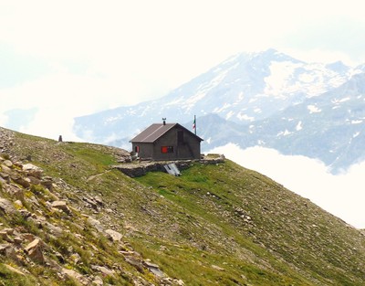
Rifugio Stellina » Refuge du Petit Mont Cenis
|
5h20 |
18.4 km
|
245 m
|
602 m
The stage runs through the Lake Moncenisio area. The landscape is stunning as are the views. It is an important area too for having been the site of many battles over the ages. After walking on the ridge along the border, the trail descends on French terrain to the abandoned hamlet of Grand-Croix before running alongside the banks of the lake and reaching the Petit Mont-Cenis hut. This leg is practicable by mountain bike, too from Gran Croix (Lake of Mont Cenis) to Col Clapier.
From the Stellina hut a trail climbs to Alpe Tour. The Via Alpina trail then runs along the French-Italian border, between milestones 12 and 14 before finally heading into France and the high plateau of Moncenisio. The trail passes through "Les Echelles", a name which refers to the winding road which climbs the small waterfalls of Cenise, using an infinite number of bridges and retaining walls, (built after the first mountain road, which was built between 1803 and 1813 and led to the high plateau at Lanslebourg). The hamlet of Grand-Croix is still testimony to the desire to conquer the mountains: in the past it was part of a chain of hostels designed to welcome travellers during any season. Its chapel, Notre-Dame des Neiges (Our Lady of the Snow) hosts a permanent exhibition on mountain pilgrims. Below the winding bends of what, even on the Italian side, is known as the “Great Ladder”, a peaceful oasis is hidden away amongst the larches: the chapel of St Nicolas, on the plain that bears the same name. The route then leads past the Mont-Cenis dam, built between 1963 and 1968. It was first put to use in 1969, and gave rise to the current lake of the same name. The Via Alpina trail skirts round it to the left, passing under the old fort of Variselle, which is part of an impressive series of forts, aimed at the protection of the important route of the Moncenisio pass. The forts are: Mont-Froid, Ronce (Roncia), Pattacreuse, La Turra (thought to be impregnable because of its ideal location) and Malamot, amongst others. But real history lovers with an interest in the Moncenisio area will not miss the opportunity to walk right of the dam to the Pyramid of the Italian-French exhibition centre, built underneath the round Fort Ronce. In fact, the pass has always been a strategic access point, contested by France, Italy, Sardinia or Savoy, proof of which is the number of fortresses erected in the area, as well as the facilities for merchants, pilgrims, emperors or other conquering kings. The exhibition brings to life the famous hostel which now lies under the waters of the lake. After the fort at Variselle, the Via Alpina trail passes below Fort Pattacreuse. From here there are views of the pass and of the high peaks behind Fort Ronce (Signal du Grand Mont Cenis, 3356m; Pointe de Ronce, 3612m; Pointe du Lamet, 3504m…). The trail then reaches the chapel of St Barthélémy and, further up, the Petit Mont-Cenis hut. (Regione Piemonte)
This route crosses the border to enter France at boundary stone 12 C along a wide sheep-track. Follow the border, then walk by the three stone buildings at Lamet. Keep going up the street which presents vertigo landscapes on its left, on the hillside. Wade a torrent (warning: big water flows after heavy rain). 2180 metres high, the border abandons the road track. Keep walking along the road, leaving the path towards Baracon des Chamois on your right. The road starts going downhill and stretches in front of two steles at “Les Pierres Blanches” (White Stones). (warning: possible landslides, be careful). The perspective widens entering the pastures to reach the ruins at Court (a big three-storey building, and ancient batteries on mountain tops on the right). Keep walking down slowly, skirt the Paradis (Heaven) mines to reach the state RN6 road. In front of you, you’ll see the huge dike’s mass. Walk down for 900 metres along RN6 (grassy slopes). (watch the heavy traffic in Summer). Walk by the private Gran Scala mountain hut, then leave the tarmac road, turn right at the old customs’ hut and reach Grand-Croix houses. After the village, take the wide path on your left which slowly climbs uphill to reach the eastern dike’s end (a road allows you to reach the Variselle Fortress in 30 minutes). Walk on along this wide path in a valley dominated by the fort. At the little peak further on, keep walking straight and down again towards one of the lake’s branches. Then follow the path until St Barthélémy’s chapel. From the chapel, take the wide path that leads to Savalin. The path narrows down; follow it until a small lake. Take the path on your left which crosses the pastures along a contour line before taking the road near the Petit Mont Cenis mountain hut again. (Michèle Looten, Jean-Pierre Séhier et Jean-Luc Galland, CDRP 73)
Natural and cultural heritage
Mount Moncenisio was the backdrop to a number of battles during World War II, and the numerous forts perched on the peaks around the lake and hidden on slopes bear witness to this. The artificial lake hides the village of Moncenisio itself, home to a famous hostel for travellers. The village was submerged by the lake in the ‘50s. The Moncenisio pass was also the route of the “Fell” railway, which linked the Susa valley to France. It used an innovative traction system to pull a small train up fairly steep inclines. The highest stretch of the line was covered by a wooden structure to protect the railway from snow and allow trains to pass even in winter. The history of the railway (of which some tunnels still remain alongside the main road from Susa to the pass) still amazes, because of the boldness of the scheme which, at the time, pushed back the very limits of existing technology.
(Regione Piemonte)
Other long-distance trails and alternative routes
Tour 2000: the trail runs along the ridge at the top of Val di Susa valley above the right bank of the Dora Riparia torrent. A number of trails lead from the French border to military forts above the Moncenisio dam: the Variselle fort, Patacreuse and Roncia. Climbs to: Pointe du Lamet; Pointe du Ronce.
Favourites, criticisms ? Make your personal comments on this stage. For more general notes please use the comments section of the page Over to the Via Alpinists.

 |
5h20 |
18.4 km
|
245 m
|
602 m
|
5h20 |
18.4 km
|
245 m
|
602 m


Favourites, criticisms ? Make your personal comments on this stage. For more general notes please use the comments section of the page Over to the Via Alpinists.