Create your own guidebook
Download track
Quality : very good
GPX KML CSV
Location
Italy
PIEMONTE
TO
MOMPANTERO-NOVALESA
VALLE DI SUSA E CENISCHIA

Key to symbols   
Stage point (start or end of stage)
Intermediate accommodation possibility
Summit
Pass
Town, village
Other locality

Catering
Doctor
Chemist
Bakery / grocery
Hardware / sports shop
Post
Bank / cash dispenser
Train
Coach
Taxi
Open automobile access

A Tarred or paved road
B Dirt track
C Mule trail
D Mountain trail
E Equipped trail (cables, ladders)
F No trail

Stroll / tourism (broad, non-exposed trail)
Hiking (mountain trail, in places narrow and exposed)
Alpine route (equipped or very exposed section, snow field, blocks)
D33 Rifugio Riposa » Rifugio Stellina
  |   6h30   |   12.3 km   |   1648 m   |   1264 m

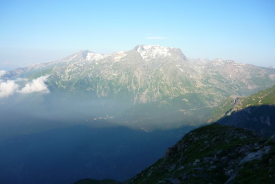
The trail climbs the uncomfortably steep slopes of Mount Rocciamelone. Its peak is the site of the highest shrine in Europe, a well-known spot for pilgrimages. After Cà d'Asti the trail follows less well-known routes. The views are excellent and the trail is certainly less frequented than routes to the top of Rocciamelone.

Point Segment
Name Services Information Marking
Rifugio Riposa
2179 m
| D  2.3 km / 2h00
Rifugio Cà d'Asti
2822 m
| D  3.1 km / 1h30
Alpe Crest
1968 m
| D  3.7 km / 0h45
Prapiano
1812 m
| D  3.2 km / 2h15
Rifugio Stellina
2567 m
Detailed route description
Natural and cultural heritage
Other long-distance trails and alternative routes
From Cà d'Asti there is access to the peak of Rocciamelone.
Useful topographic maps
  • ASFn°13 ~ IGN (1:25.000)
  • 2 ~ IGC Valle di Lanzo e Moncenisio (1: 50000)
Useful guidebooks
  • Camminaitalia, Cannonini, Carnovalini, Valsesia ~ CAI-TCI (ISBN 1995)
  • Andar per rifugi, Bersezio, Tirone ~ De Agostini (ISBN 1988)
Comments

Favourites, criticisms ? Make your personal comments on this stage. For more general notes please use the comments section of the page Over to the Via Alpinists.


max. 1000 characters
  • pierre sasso - 2024-03-04
    bonjour
    avez vous de la place pour la nuit 26 août 2024 pour 4 personnes
    merci pour votre réponse
    cordialement
  • FX - 2023-10-14
    Itinéraire réalisé de Riale (D1) à MontCenis (D34) du 19/08 au 12/09/23.

    Pour suivre le parcours prévu jusqu'à Refuge Stellina, suivre trace GPX D33 (https://www.openrunner.com/route-details/17072323).

    Sur ce parcours nous avons privilégié une variante permettant d'aborder le Rocciamelone par l'arrière en venant du Refuge Tazzeti et du glacier : cf. D32 variante (https://www.openrunner.com/route-details/17804461) et D33 variante (https://www.openrunner.com/route-details/17804604).

    Le refuge Stellina marque le point de jonction entre voie classique et variante.
  • Mouro - 2023-08-10
    2023, Monaco-Trieste. We followed the Refuge Stellina's guards advice and took the passage by Col de Novalèse (3200 mt). The climb to the col is strenuous, and orientation at the top, in order to find the track downards on the other side, demands care and attention, namely because of the proliferation of misleading cairns (no red/white marks).
  • Samuel - 2022-08-22
    Parcouru le 7 août 2022, c'est une catastrophe ! Chemin difficile à suivre car peu usité et raide (même si beaucoup de marquage), mais les passages de ruisseaux/ravins descendant du Rocciamelone sont très ravinés, raides, et dangereux pour trouver un passage. Une fois passés, les berges sont plein de bois morts et rendent la progression dangereuse et pas simple de retrouver la faible trace. Bref, ne passez pas par là et la Via Alpina mérite mieux à cet endroit !
  • aHiker - 2022-06-22
    The dangerous passage mentioned before is still in that same state. I am well equipped with GPS, emergency beacon and maps, but that passage in the fog was something else. How stupid can you be not to change signage for SIX years?! I can't imagine how less fit or experienced people suffer if it was like that for me...
  • Anthony PINOT - 2022-02-20
    Passage très dangereux entre les granges Prapiano et l'Alpe Crest, disparition totale du sentier sur certaines portions suite à un glissement de terrain, laissant place à canyons aux pentes raides, puis quasi absence de balisage (effacé ou presque) à certains endroits. Aménagement nécessaire et/ou indication claire du niveau d'engagement du tracé
  • Elise - 2020-10-02
    Cela fait plusieurs années que le problème du passage entre Alpe Crest et le Rifugio Stellina est signalé comme mal balisé et dangereux, ce qui justifierai soit une modification d'itinéraire, soit un aménagement. Un aménagement serait préférable car c'est un beau parcours.
  • santiago robetto - 2017-10-10
    busco grupo de trekking para ascender al rocciamelone
    Automatic translation [Google]
    I am looking for a trekking group to ascend to the rocciamelone
  • Peter - 2016-08-31
    Achtung: Die Passage zwischen Alpe Crest und Prapiano ist nur schwer begehbar und gefährlich. Es gibt 2 tiefe Bachläufe mit viel Geschiebe bei denen eine Absturzgefahr besteht. Bei Regenwetter ist eine Passage m.E. nicht möglich.
    Automatic translation [Google]
    Attention: The passage between Alpe Crest and Prapiano is difficult to walk and dangerous. There are 2 deep streams with much attachment in which there is a danger of falling. In rainy weather a passage in my opinion is not possible.
  • Sylviane - 2015-08-23
    Passage sur la via alpina le 22 août 2015 entre le refuge CA d'Asti et Alpe Tour en passant par l'Alpe Crest, Prapiano et sous l'Alpe Carolei : le balisage est correct depuis le refuge, mais dans la brume assez difficile à suivre, mais surtout le balisage est très difficile à retrouver au-dessus de l'Alpe Crest et jusqu'aux granges Brigard. Utilisation du GPS indispensable. De plus, un orage très violent (vendredi 14/08/2015) a emporté le sentier dans les traversées de torrent : plusieurs passages très problématiques et un très dangereux
    Automatic translation [Google]
    Passage via alpina on August 22, 2015 between CA and refuge Alpe d'Asti Tour through Alpe Crest, Prapiano and under Alpe Carolei: the markup is correct from the refuge, but the fog rather difficult to follow, but mostly the markup is very difficult to recover above the Alpe Crest Brigard and even barns. Using the GPS essential. Moreover, a very violent storm (Friday, 08/14/2015) won the trail in the river crossings: several very problematic passages and a very dangerous
  • BASSO - 2014-08-02
    la liaison Stellina Riposa est rendue délicate du fait de la difficulté a suivre l'itinéraire d'Alp Carolei a Ca d'Asti le balisage tres ancien demande beaucoup d'attention la traversée de 2 ravins detritiques est délicate
    le gestionnaire du refuge riposa n'est pas au fait d'etre sur le poste d'etape de la via alpina
    impossibilité de se renseigner sur la meteo ou l'etape suivante,itinéraire déconseillé par temps incertain
    Automatic translation [Google]
    Stellina Riposa the connection is made difficult because of the difficulty to follow the route has Carolei Alp d'Asti Ca markup very old demand a lot of attention to cross two ravines detrital is delicate manager of the refuge riposa n ' is not the fact of being on the stage of the Via Alpina unable to learn about the weather or the next step post route recommended by uncertain weather
  • Sabine_Bade - 2011-10-18
    Wie ich gerade erfahren habe, ist der Teilabschnitt zwischen Alpe Prapiano und Alpe Crest von Wegearbeitern im Oktober 2011 wieder vollkommen instand gesetzt. Auch nagelneue Wanderwegweiser wurden aufgestellt.

    Sabine Bade
    Automatic translation [Google]
    As I have just learned the section between Alpe Alpe Prapiano and Crest of ways workers in October 2011 has been put back completely repaired. Also brand new hiking guide have been provided. Sabine Bade
  • m.keller - 2011-06-23
    Entre refuge Ca d'Asti (2854m) et AlpeCrest (2000m), le profil altimétrique est faux. Il y a uniquement une descente régulière de -854m.
    Attention : En 2010, on ne pouvait pas aller directement de AlpeCrest à Stellina comme c'est indiqué sur le profil altimétrique.
    Il fallait faire AlpeCrest (2000m) Novalesa (828m) et remonter à Stellina (2600m)
    ou faire Ca' d'Asti (2854m), Rocciamelone (3528m) et descendre à Stellina, avec des crampons.
    Automatic translation [Google]
    Between Ca d'Asti refuge (2854m) and AlpeCrest (2000m), the elevation profile is incorrect. There is only one regular-854m descent. Caution: In 2010, you could not go directly to Stellina AlpeCrest as indicated on the elevation profile.  We had to AlpeCrest (2000m) Novalesa (828m) and back to Stellina (2600m) or to Ca 'd'Asti (2854m) Rocciamelone (3528m) and descend to Stellina, with crampons.
  • campi mario - 2011-06-23
    il profilo altimetrico indica che dal rifugio Cà d'Asti all'alpe Crest c'è un profondo saliscendi, si scende a 2307 m. per poi risalire a 2796 m. per poi scendere di nuovo all'Alp Crest ; mentre nella descrizione dettagliata si dice che il sentiero perde quota dal rifugio Cà d'Asti sino all'Alpe Crest. Quale è la descrizione giusta?
    Automatic translation [Google]
    the elevation profile indicates that the shelter Alpe d'Asti Ca Crest is a deep and down, you go down to 2307 m. and then up to 2796 m. before falling back to Alp Crest, while the detailed description it says that the path loses altitude from the refuge to the Alpe d'Asti Ca Crest. What is the right description?
  • sportbiehly - 2010-08-28
    Bin versehentlich den Weg ab Alpe Crest nach Prapiano gegangen, da ich noch alte Karten hatte. Das Schild in Richtung Prapriano wurde scheinbar entfernt, aber es steht kein Hinweis über die Sperrung. Die Markierung ist logischerweise noch überall gut sichtbar. Kurz vor der Furt war es wegen der vielen umgeknickten Bäume recht schwierig weiterzukommen und die beiden Furten sind extrem tief und breit geworden. Den Weg auf der anderen Seite wiederzufinden war entsprechend schwierig. In der neuen IGC Karte ist der Weg nicht mehr verzeichnet.
    Automatic translation [Google]
    I accidentally went off the road to Alpe Crest Prapiano, since I still had old maps. The sign for Prapriano was removed apparently, but there is no evidence of this bar. The mark is obviously still visible everywhere. Shortly before the ford it was to get ahead because of all the bent-over trees rather difficult and the two Fords have become extremely deep and wide. Rediscover the path on the other side was extremely difficult. In the new IGC map the route is no longer listed.
  • M.Keller - 2010-08-21
    Zone encore interdite en juillet 2010 (bien que stabilisée) entre Prapiano et Alpe Crest.
    Dans le sens Stellina/Riposa:
    2 solutions :
    1) De Stellina monter au Rocciamelone, mais très enneigé en début d’été et redescendre au refuge Ca’ d’Asti.
    2) De Stellina descendre à Novalesa ( 1770m de descente !), ensuite direction Santa Anna, puis sentier qui remonte aux Granges Traverse et Granges Monio (Bivacco annoncé à plusieurs reprises sur le parcours mais non indiqué sur les cartes).
    - Au départ du Bivacco, monter à Granges Pendente et Alpe Crest. Entre G. Pendente et A. Crest, pas de balisage, pas de chemin clair. Il faut monter à la boussole et l’altimètre.
    - A Alpe Crest on rejoint la VA venant de Stellina, mais comme le chemin n’est plus utilisé depuis 2 ans, les marques disparaissent et les balises sont difficiles (mais pas impossibles) à repérer dans l’herbe ou les rochers jusqu’à Ca’ d’Asti.

    - A Ca’ d’Asti on peut prendre le chemin AV(Alta Via di val di Suza) qui reste en balcon, ne descend pas au refuge Riposa, et rejoint la VA quelques km avant Cap Rivetto. Un gué délicat à passer. Prudence !

    Pour tous renseignements sur la remise en état du tronçon problématique, ou sur l’enneigement du sommet du Rocciamelone , s’adresser à :
    M. Francisco Foglia (parle le français)
    (responsable du refuge Stellina)

    (tel : 348 793 23 30 ou mob: 347 767 55 46

    Autre possibilité: Petit Mt Cenis/Novalesa/ refuge de Riposa. On doit utiliser la route.
    Automatic translation [Google]
    Area still banned in July 2010 (although stabilized) between Prapiano and Alpe Crest. In the sense Stellina / Riposa: 2 solutions: 1) From Stellina Rocciamelone climb, but very snowy in early summer and down to the shelter Ca 'd'Asti.  2) From Stellina down to Novalesa (1770m descent!), Then towards Santa Anna, then back to the trail and Granges Granges Traverse Monio (Bivacco repeatedly announced on the course but not shown on maps). - At the start of Bivacco, ride Alpe Granges Pendente and Crest. Between G. Pendente and A. Crest, no markup, no clear path. Must be fitted with a compass and altimeter. - A Crest on Alpe joined the VA from Stellina, but the road is not used for 2 years, marks disappear and the tags are difficult (but not impossible) to find in the grass or rocks to Ca 'd'Asti. - At Ca 'd'Asti can take the path AV (Alta Via di Val di Suza) which remains balcony, does not fall Riposa refuge, and joined the VA a few miles before Rivetto Cap. Ford tricky to pass. Caution! For information on the rehabilitation of the section problem, or snow from the top of Rocciamelone, please contact: Francisco M. Foglia (speaks French) (Head of refuge Stellina) (Tel: 348 793 23 30 or mob: 347 767 55 46 Another possibility: Small Mt Cenis / Novalesa / Riposa refuge. You must use the road.
  • Sabine_Bade - 2010-08-10
    Auch im Jahr 2010 raten die Hüttenwirte vom Rif. Stellina und Cà d‘Asti von der Begehung des Weges zwischen Alpe Prapiano und Alpe Crest ab.

    Alternative Routen siehe Posting vom 26.09.2009.

    Sabine Bade
    Automatic translation [Google]
    Also in 2010, advised the lodge hosts the Rif. Stellina and Cà d'Asti from the commission of the path between Alpe Alpe Prapiano and from Crest. Alternative routes see posting from 26.09.2009. Sabine Bade
  • ROUSSELLE - 2010-01-04
    De passage le 16 août 2009, la traversée est interdite par arrété municipal entre l'Alp Prapiano et l'Alp Crest à cause de chutes de pierres bien réelles, provenant du Rocciamelone. Il faut donc monter au Rocciamelone si la météo et les conditions physiques le permettent ou plus simple mais plus long, redescendre à Novalese et remonter par Santa Anna, les granges Castellana, la chapelle Traverse pour atteindre la piste au point côté 1659
    Automatic translation [Google]
    Passing August 16, 2009, the crossing is prohibited by municipal stopped between Alp and Alp Prapiano Crest because of rockfall real, from Rocciamelone. It is therefore up to Rocciamelone if weather and physical conditions permit or easier but longer, and back down to Novalese by Santa Anna, barns Castellana, Chapel Traverse track to reach the 1659 point side
  • Sabine_Bade - 2009-09-26
    Anfang August 2009 kam es erneut zu mehreren Geröllabgängen im Teilabschnitt zwischen Alpe Prapiano und Alpe Crest, die Schneisen in den Weg gerissen haben (kurz hinter der Punta Falconera bei ca. 45°11'54'' 07°02'57''). Im Rifugio Stellina hängt (hing zumindest noch vor 4 Wochen) ein Aushang, dass der Weg gesperrt sei.

    Obwohl auf dem Wegstück selbst Hinweise darauf oder Absperrungen fehlen, ist davon abzuraten, diesen Weg momentan zu gehen.

    Als Alternative besteht die Möglichkeit, a. über den Colle della Novalesa direkt zum Rocciamelone aufzusteigen (nur bei stabiler Witterung, Trittsicherheit und Schwindelfreiheit) oder vom Stellina Richtung Süden bis Alpe Prapiano abzusteigen, dort ein Stück weit der Piste folgen, die nach Novalesa führt, und dann auf der ‚Via dei Monaci‘/ ‚Via di Novalesa‘ bis zur Grange Pendente gehen. Dort führt ein Wanderweg hinauf zur Alpe Crest, wo man wieder auf die Alta Via/ Via Alpina trifft.
    Automatic translation [Google]
    Early August 2009, there was another more debris disposal in the section between Alpe Alpe Prapiano and Crest, ripped the aisles in the way have (just behind the Punta Falconera at approximately 45 ° 11'54'' 07 ° 02'57''). The Rifugio Stellina hangs (hung at least before 4 weeks) a notice that the road was blocked. Although evidence on the part of the path itself or missing barriers is not advisable to go this way at the moment. Alternatively there is the possibility a crossing Colle della Novalesa directly ascend to Rocciamelone (for stable weather, sure-footedness and vertigo) or from Stellina descend south to Alpe Prapiano there some way the slopes follow that leads to Novalesa, and then go to the Via dei Monaci '/, Via di Novalesa' to Grange Pending. There, a trail leads up to the Alpe Crest, where you will meet again on the Alta Via / Via Alpina.
  • fabio - 2009-08-13
    tracce su ghiaione visibili; poi si perdono sui traversi e nei prati sopra alpe Prapiano
    Automatic translation [Google]
    visible traces of gravel, then you lose on the bars and in the alpine meadows above Prapiano
Last update : 2013-06-14