Create your own guidebook
Download track
Quality : very good
GPX KML CSV
Location
Italy
PIEMONTE
TO
BALME -USSEGLIO
VALLE DI VIU'

Key to symbols   
Stage point (start or end of stage)
Intermediate accommodation possibility
Summit
Pass
Town, village
Other locality

Catering
Doctor
Chemist
Bakery / grocery
Hardware / sports shop
Post
Bank / cash dispenser
Train
Coach
Taxi
Open automobile access

A Tarred or paved road
B Dirt track
C Mule trail
D Mountain trail
E Equipped trail (cables, ladders)
F No trail

Stroll / tourism (broad, non-exposed trail)
Hiking (mountain trail, in places narrow and exposed)
Alpine route (equipped or very exposed section, snow field, blocks)
D31 Balme » Usseglio
  |   7h00   |   12.5 km   |   1251 m   |   1436 m

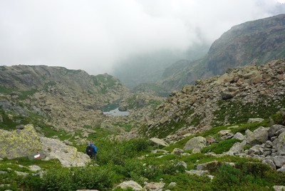
From Balme the stage climbs the steep slopes typical of the Lanzo valleys, and leads to the Paschiet pass at 2435 metres. The pass leads from the Vale of Ala to the Vale of Viù, and the hamlet of Usseglio, well-known tourist resort at the bottom of the valley.

Point Segment
Name Services Information Marking
Balme
1457 m
| D  5 km / 3h00
Bivacco Gandolfo
2160 m
| D  2.1 km / 1h20
Passo Paschiet
2442 m
| A  5.4 km / 2h40
Usseglio
1266 m
Detailed route description
Other long-distance trails and alternative routes
The trail largely follows GTA stage 224. It is possible to climb to the following peaks: Torre d'Ovarda, Cima Chiavesso, the eastern and western peaks of Mount Ortetti.
Useful topographic maps
  • 2 ~ IGC Valli di Lanzo e Moncenisio (1: 50000)
Useful guidebooks
  • Alpi Graie Meridionali, G.Berutto, L.Fornelli ~ CAI-TCI (ISBN 1980)
  • Camminaitalia, Cannobini, Carnovalini, Valsesia ~ Le guide di Airone, Mondadori (ISBN 1995)
Comments

Favourites, criticisms ? Make your personal comments on this stage. For more general notes please use the comments section of the page Over to the Via Alpinists.


max. 1000 characters
  • FX - 2023-10-14
    Itinéraire réalisé de Riale (D1) à MontCenis (D34) du 19/08 au 12/09/23.
    Chemin très bien balisé permettant de monter dans une zone très minérale et de découvrir les magnifiques Laghi Verdi.
    Un peu plus haut le Bivacco Gondolfo est une structure métallique très propre avec table/bancs et 2 niveaux de couchages. Possibilité de faire du feu aux emplacements existants pour se réchauffer quand le soleil disparait derrière les cols.
    Les parties suivantes, en zone gravière très bien marquée par le Passo Paschiet et di Costa Fiorita sont de toute beauté.
    Descente jusqu'à Usseglio, ses grandes Albergo de luxe, ses villas anciennes, ses vieilles maisons et son Bivocco Maternali, un bar épicerie incroyable, où se presse toute la population locale.
    Trace GPX : https://www.openrunner.com/route-details/17072292
  • JeanCat - 2022-11-02
    A Balme, super accueil à l'Auberge des Montagnards où le patron cuisine merveilleusement.
  • robert - 2014-07-10
    Sentier bien balisé mais exposé par endroits . Le minimarket d'Usseglio est fermé le mercredi et ouvert uniquement le matin le lundi et mardi
    Automatic translation [Google]
    Well marked trail but exposed in places. The minimarket of Usseglio closed Wednesdays and open only in the morning on Monday and Tuesday
  • tarjako - 2013-07-21
    I divided this stage in two: stayed in Bivacco Gino Gandolfo, brand new madrasses and pillows! No apparent water supply thoug. Continued to Usseglio next day and saw a large herd of steinbocks!
  • Sabine Bade - 2013-02-26
    In Balme wurde das als Posto Tappa dienende 'Albergo Camussot' Anfang 2012 geschlossen.
    Antonella und Guido Rocci betreiben nun das 'Les Montagnards'. Nähere Infos unter
    http://westalpen.wordpress.com/2012/06/27/montagnards/
    Sabine
    Automatic translation [Google]
    In Balme serving as Posto Tappa 'Albergo Camussot' was closed in early 2012. Antonella Guido Rocci and now operate the 'Les Montagnards'. More details at http://westalpen.wordpress.com/2012/06/27/montagnards/ Sabine
  • Peter - 2011-09-12
    Im augstieg von balme ist das biwak “gino gandolfo“ zu empfehlen (tolle lage, platz für zirka 8 personen). am colle di fiorita (wo der letzte lange abstieg beginnt) folgt man den spuren nach links. Abstieg steil und etwas verwachsen, aber ausreichend erkennbar.
    Automatic translation [Google]
    In augstieg of balme the bivouac "gino Gandolfo" is recommended (great location, place for about 8 people). on Tues fiorita colle (where the last long descent begins) follow the trail to the left. Steep descent and a bit overgrown, but sufficiently obvious.
  • Martine keller - 2011-06-16
    Dans le sens Usseglio - Balme :
    Balisage assez inégal qui occasionne beaucoup d'erreurs et de pertes de temps en début d’étape. Après Usseglio, ne pas prendre les traces qui, à la fin de la digue canalisant le torrent, mènent dans la friche. Le chemin s’engage sur le remblai empierré, s’enfonce entre les arbres et monte. Le sentier est étroit mais évident et balisé. Après, au cours de la montée, les balises ne sont pas toujours bien placées aux bifurcations ; il faut veiller à ne pas prendre les traces qui conduisent au torrent, mais suivre celle qui reste visible et qui est épisodiquement marquée.
    Automatic translation [Google]
    In the sense Usseglio - Balme: Markup rather uneven which causes a lot of mistakes and wasted time in the early stage. After Usseglio, do not take the traces at the end of the dike channeling torrent, lead in the wasteland. The path the embankment gravel, sinks and rises through the trees. The trail is narrow but clear and marked. Afterwards, during the ascent, the tags are not always well placed to bifurcations, care must be taken not to take the trail leading to the river, but follow that which is visible and is occasionally marked.
  • fabio - 2009-08-13
    discesa da colle di costa fiorita (2465 non citato in relazione: da Paschiet 250m giù, poi su) ripida spesso esposta, vaghe tracce invase da vegetazione, bolli poco visibili; in basso lungo tratto su caotici resti di valanga
    Automatic translation [Google]
    descent from the hill of flowery coast (2465, not mentioned in the report: Paschiet from 250m down, then up) steep often exposed, vague traces invaded by vegetation, stamps little visible down long stretch of chaotic remains of avalanche
Last update : 2014-07-23