Alpiner Weg (drahtseilgesicherte oder besonders ausgesetzte Stelle, Firn, Blockhalde)
R40
Kellerjochhütte » Schwaz
|
6h05 |
15.7 km
|
614 m
|
2063 m
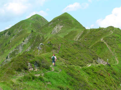
Eine aussichtsreiche Etappe mit Endziel Silberstadt Schwaz steht bevor. Der Anstieg zur Kellerjochhütte ist ziemlich steil, aber die gemütliche Hütte kann mit allem aufwarten, was das Wanderherz begehrt. Entweder über die Alte Kellerjochhütte oder aber dem Grat folgend über Kreuzjoch und Gratzenkopf gelangt man in die Stadt Schwaz, die durch den Silberabbau Berühmtheit erlangte.
Vom Loassattel folgt man dem Weg in Richtung Kellerjochhütte, d.h. vom Wirtshaus Gamsstein bzw. Loas ein Stück zurück und dann links bergan. Der Steig führt steil aufwärts, anfangs noch durch lichten Bergwald, der etwas Schatten bietet, später aber über alpine Rasen mit Almrausch und Latschen. Außer dass es an schönen Tagen ziemlich heiß sein kann, bietet der Anstieg einen wunderbaren Blick auf das Karwendel, das Inntal und auch auf das Sonntagsköpfel und den Gilfert. Kurz unterhalb des Kuhmösers wird der Weg flacher, führt sogar ein Stück entlang der Hangflanke abwärts. Ab hier kann man bereits die Kellerjochütte sehen, die in besonders schöner Aussichtslage errichtet wurde. Nach einem letzten Anstieg erreicht man nach 2h die Kellerjochhütte. Von hier gibt es mehrere Möglichkeiten des Abstiegs: Für nicht-schwindelfreie Personen kann der Abstieg über die Alte Kellerjochhütte und die Proxenalm empfohlen werden. Wer über Schwindelfreiheit und Trittsicherheit verfügt, sollte den sehr schönen und aussichtsreichen „Alpinsteig“ über die Kapelle wählen. Gleich hinter der Hütte führt ein mit Drahtseilen versicherter Steig zur Kapelle auf dem Kreuzjoch (ca. 30min). Von dort führt links ein steiler Pfad bergab zum Kellerjoch, wo man dem Wegweiser in Richtung Gratzenkopf folgt. Der Weg ist schon vom Kellerjoch gut zu sehen und führt genau am Grat entlang. Bei den zwei folgenden Weggabelungen hält man sich jeweils links und erreicht nach ca. 1h 30min das Gipfelkreuz des Gratzenkopfes. Nach dem Gratzenkopf führt der Weg in einer Linkskurve bergab. Anfangs noch über langes Gras (Vorsicht bei Nässe), später in engen Serpentinen durch dichter werdenden Wald bis man die Forststraße von der Proxenalm kommend erreicht. Dieser folgt man rechter Hand der Beschilderung in Richtung „Schwaz – Zintberg – Pirchner Aste“. Mehrere Abzweigungen durch den Wald sind gut gekennzeichnet und rot markiert. Die Pirchner Aste bietet auf halbem Weg des Abstiegs Rastmöglichkeiten und lädt zur Jause ein. Nach einem letzten Stück durch Wald erreicht man die Asphaltstraße des Zintberges. Dieser folgend, über mehrere Kehren erreicht man nach ca. 1h30min (von der Pirchner Aste) die Silberstadt Schwaz. Schon beim Abstieg hat man einen guten Blick auf Schloss Freundsberg, das man über einen Abstecher auf dem Fußweg leicht erreichen kann. Von der Forststraße zur Proxenalm zweigt linker Hand der Steig zum Gratzenkopf ab. Auf die Markierung achten, damit man diesen nicht übersieht. (Christina Schwann, OeAV)
Natur- und Kulturerbe
Der Hufeisenförmige Bergstock des Kellerjochs ist die höchste Erhebung im nordöstlichen Zipfel der Tuxer Alpen. Die relativ bescheidene Gipfelhöhe sollte nicht zu voreiliger Geringschätzung verleiten, denn mit 1.800m Höhenunterschied zum Inn ist der felsdurchsetzte Kamm ein überragender Aussichtspunkt über dem Inntal. Von der Kellerjochhütte der Sektion Schwaz des Oesterreichischen Alpenvereins kann man über einen etwas ausgesetzten aber gut versicherten Steig zu der kleinen Kapelle am Kellerjoch gelangen und genießt einen atemberaubenden Blick in das Karwendel und ins tief unten liegende Inntal. Abgeschirmt durch die hohen Berge im Norden und die etwas niedrigeren Gipfel der Tuxer Alpen im Süden, die genügend Sonnenschein bis auf den Talboden durchlassen, ist das Inntal klimatisch sehr begünstigt. Die warmen Winde des Föns wirken sich zudem positiv auf die Vegetation - wenn auch nicht immer so gut auf wetterfühlige Personen - aus. Früher war das Inntal vor allem eine große sumpfige Landschaft, heute wird das Bild primär von der Landwirtschaft, Industriegebieten und der Inntalautobahn beherrscht. Schon beim Abstieg über den Zintberg gelangt man an die Abzweigung des Fußweges zum Schloss "Freundsberg", in dessen Turm sich das Schwazer Bergbau- und Heimatmuseum befindet. Das Schloss ist eines der Wahrzeichen des Unterinntals. Die Erste Namensgebung geht bis auf das Jahr 1128 zurück. Schwaz, die "Silberstadt", wie sie auch genannt wird, wird seit eher vom Bergbau geprägt. Der wirtschaftliche Reichtum der Stadt im 15. Jahrhundert wirkte sich auch kulturell überaus positiv aus. Und obwohl die Stadt im Tiroler Freiheitskampf von 1809 fast vollkommen niedergebrannt wurde, zeugen noch heute viele Bauwerke vom Glanz der alten Zeit. Vor allem die Pfarrkirche "zu Unserer Lieben Frau", die die größte gotische Kirche Tirols darstellt, das Franziskanerkloster mit seinem Kreuzgang, das Fuggerhaus und das Rathaus gehören zu diesen sehenswürdigen Bauwerken. Berühmte Persönlichkeiten, wie im 15. Jahrhundert Hans Sachs, Paracelsus oder Kaiser Maximilian, waren Gäste in der Silberstadt. Und auch heute treffen sich weltberühmte Künstler zu einem Stelldichein in der schönen Stadt im Unterinntal. Erwähnenswert sind dabei vor allem das "Klangspuren-Festival" und das "Avantgarde Schwaz", die über die Grenzen Tirols hinaus Bekanntheit erlangt haben. (Christina Schwann, OeAV)
Andere Weitwanderwege und Varianten
Besteigung des Kuhmösers, Besteigung des 2344m Kreuzjoches mit Kapelle.
Nützliche topografische Karten
Nr. 5/3 Karwendelgebirge Ost ~ Oesterreichischer Alpenverein (1:25.000)
Geheimtipp oder Kritik? Geben Sie Ihren eigenen Kommentar zu dieser Etappe ab. Für allgemeinere Bemerkungen, nutzen Sie bitte die Funktion Kommentar der Seite Via Alpinisten am Wort.
Carsten - 10.01.22
[4] Excellent resupply in Schwaz. Start at the Stadtgalerien (just before the river, on the left, the Via Alpina passes it, with supermarket as well as DM and Muller markets, the latter two carrying their usual range of health foods). Past the train station (whose pedestrian underpass one has to use) is a Hofer/Aldi. Prices in Schwaz are about half of what they were in Sexten or Finkenberg.
Carsten - 10.01.22
[3] About 5km before Schwaz one reaches an asphalt road and a bus stop, Pertrach (buses run almost every hour to Schwaz). The guidebook says walk the road into town. The app Maps.me shows a hiking trail that takes off in the second far (East) curve down; signposts appear 5min into the trail, but where it starts from the asphalt road there is only a sign about a "Rodelbahn"; this somewhat rough trail descends rapidly along a creek and then moves diagonally away from the creek, crosses the asphalt road, and continues as a forest trail to the
very edge of Schwaz. Another option at Pertrach is to follow the signs to "Burg Freundsberg" with a trail that seems to continue through nice old forest; the GPS waypoints for the Via Alpina lead to within 300m and 100m altitude (below) the Burg, so from the Burg it's just a matter of descending to rejoin the GPS route.
Carsten - 10.01.22
[2] If one goes to the Kellerjochhuette, one has 3 possibilities to continue: (1) Follow the GPS waypoints, which means an about 2km slope crossing (the slope is at a 70-80 degree angle but the trail is good, albeit narrow, early on secured with c.200m of cables that aren't necessarily needed, and the slope is covered in grass and small bushes), or (2) walk around the Kellerjochhuette and find the spur trail down to the highline trail (from afar, this looked like the easiest option; it will likely provide an incentive to bypass the Gratzenkopf, or (3) continue from the hut to the chapel and continue from there to rejoin the GPS waypoints; the trail to the chapel (300-500m) may look challenging, being secured with cables in the beginning, but to judge from conversations with other hikers, could yet be easier than (1) (which I took).
Carsten - 10.01.22
[1] Ascending towards the Kellerjochhuette from the Gamssteinhaus at the beginning of R40, after about 15 minutes signposts give two options to reach the Kellerjochhurtte: straight up, or via a highline trail ("Hochebenweg") circling around the mountain and then ascending a spur to the hut. Both are signposted with the same time (I think it was 1 3/4 hours). Unless one wants to spend the night at the hut or for some other reason wishes to go up there, the highline trail *without* final ascent (bypass the hut, since one has to descend to 550m altitude Schwaz afterwards -- why add another 500m elevation gain to what’s already a big drop?) for no real gain -- may well be preferable. Where the spur trail branches off the highline trail to go up, one can continue the highline trail and either start descending to Schwaz (on trails) or continue in order to rejoin, after a bit of ascent, the GPS waypoints of the Via Alpina to go to the Gratzenkopf (a lower peak).
Lolo - 31.07.19
Hebergement à Schwaz à Einhorn Schaller...très bien (56€ : nuit + petit dej). Resto fermé ce jour là.
Automatische Übersetzung
[Google]
Unterkunft in Schwaz in Einhorn Schaller ... sehr gut (56 €: Nacht + Frühstück). Resto an diesem Tag geschlossen.
POPEYE GG - 01.02.19
Dimanche 17 juin 2018
Descente aisée sur Schwaz (nous en avions fait la moitié la veille pour cause de difficulté d'hébergement!).
A Schwaz, personne à la Pension Clara; il y avait la fête du village, peut-être en est-ce la raison?
Du coup, nous avons filé jusqu'à Stanz, sur l'autre rive de l'Inn, pour nous rapprocher un peu pour l'étape suivante. Nous avons trouvé à l'Hotel Garni Appartments Kastner (130€ pour 3).
Automatische Übersetzung
[Google]
Sonntag, 17. Juni 2018 Leichte Abfahrt auf Schwaz (wir hatten den halben Tag vorher wegen Unterkunftsschwierigkeiten!). In Schwaz niemand in der Pension Clara; da war das dorffest, vielleicht ist das der grund? Wir fuhren also nach Stanz, auf der anderen Seite des Inn, um der nächsten Etappe etwas näher zu kommen. Wir fanden im Hotel Garni Appartments Kastner (130 € für 3).
Gamssteinhaus was closed (on a Saturday), but it's a great camping spot. Unfortunately I couldn't do the ridge hike to the Kellerjoch Hütte, the weather was too unstable, but there is a good alternative route that goes via Proxenalm.
Automatische Übersetzung
[Google]
Das Gamssteinhaus war an einem Samstag geschlossen, aber es ist ein großartiger Campingplatz. Die Gratwanderung zur Kellerjoch Hütte konnte ich leider nicht machen, das Wetter war zu instabil, aber es gibt eine gute Alternative, die über die Proxenalm führt.
In Schwaz you will stay at Pension Clara, just some 100m from the stage end-point. €38 B&B. Ask anybody for the way. Or walk down to the river, and turn right 300m to the tourist office.
Automatische Übersetzung
[Google]
In Schwaz wohnen Sie in der Pension Clara, nur etwa 100 m vom Etappenendpunkt entfernt. 38 € B & B. Fragen Sie jemanden nach dem Weg. Oder gehen Sie zum Fluss hinunter und biegen Sie nach 300 m rechts ab zum Fremdenverkehrsamt.
Elisabeth - 24.12.12
Depuis le refuge Kellerjochhütte, la variante par le Gratzenkopf est jolie mais beaucoup plus longue.
Automatische Übersetzung
[Google]
Von der Hütte Kellerjochhütte ist Variante durch Gratzenkopf hübsch, aber viel länger.
Jean-Louis GIRAUD - 28.03.12
Compte tenu du trés mauvais temps et des prévisions météo, je n'ai pas souhaité dormir à SCHWAZ mais plutot avancer sur la prochaine étape R41...Je me suis finalement arrété au monastère Bénédictin de St GEORGENBERG-FIECHT. Ce soir là , il y avait de la place et j'ai été trés bien accueilli .
J'ai également pris le repas du soir et le petit déjeuner dans un réfectoire de l'abbaye .
Automatische Übersetzung
[Google]
Angesichts der sehr schlechtem Wetter und Wettervorhersagen, habe ich nicht wollen SCHWAZ sondern den nächsten Schritt schlafen R41 ... ich endlich gestoppt am Benediktinerkloster St-Georgenberg Fiecht. An diesem Abend gab es Raum, und ich wurde sehr gut aufgenommen.
Ich hatte auch Abendessen und Frühstück im Refektorium der Abtei.
Von der Rastkogel oder kellerjochhütte zweiegt der "INntaler Höhenweg" Richtung Innsbruck ab, das ist eine Variante des Roten weges, über Lizumer- und Glungezerhütte zum Patscherkofel. Details unter www.glungezer.at

 |
6h05 |
15.7 km
|
614 m
|
2063 m
|
6h05 |
15.7 km
|
614 m
|
2063 m


Geheimtipp oder Kritik? Geben Sie Ihren eigenen Kommentar zu dieser Etappe ab. Für allgemeinere Bemerkungen, nutzen Sie bitte die Funktion Kommentar der Seite Via Alpinisten am Wort.